I am not doing a general book review of Pranay Lal's book Indica: A Deep Natural History Of The Indian Subcontinent. For that, I recommend this
fine literate piece by Pratik Kanjilal published in the Indian Express. And Prabha Chandran
writes about it in the Huffington Post. Both are aimed at the general reader.
No one has, as far as I know, written critically about the science content of the book. I read through the book and have some comments on the geology.
Before I start, let me say that I enjoyed this book. Pranay Lal has read widely, traveled far, and has had immersive discussions with geologists and paleontologists. The best sections of the book are when he is writing about the many fossil finds preserved in Indian sedimentary basins and their importance in interpreting paleo-geography, ecology and evolution. He certainly appears more comfortable writing about these themes than he is about geology.
There are many problems with the geology writing. Some are easy-to-fix errors, while others will, in my opinion, require some rethinking on the more effective presentation of ideas and processes.
Let's begin with the easy to fix errors-
1) Page 12: Ref: Structure of the earth-
"The innermost shell of the "core" was composed of iron and nickel and was surrounded by a larger but less dense mass of molten iron called mantle". - The
mantle which is the layer of the earth between the crust and the core is not molten. It is solid and is made up of silicates and not iron. The core itself has two layers, a solid inner core and an outer fluid layer made up of iron and nickel.
2) Page 13: Ref: Age of corals in Rajasthan and Kutch- "
This coral colonized the seas about 380 million years ago". There are no 380 million year old sedimentary rocks in Rajasthan and Kutch (Devonian Period). This may be a typo. There are
Jurassic age corals in Jaisalmer. They are about 170 million years old.
3) Page 45: Ref: Banded Iron Formations- "
Both ferric iron and ferrous iron began to settle as successive bands at the bottom of the iron-rich seas and lakes as oxygen levels fluctuated. Once, deposited, the layers hardened one above the other and gave the appearance of a layered cake- thin strawberry-jam-coloured striations of highly oxidized iron (ferric oxide, Fe2O3) and dark coloured chocolate lines of less oxidized iron (ferrous oxide, FeO)" - In the vast majority of Banded Iron Formations the strawberry coloured striations are forms of silica, either chert or jasper. The dark coloured layers are hematite or magnetite ( ferric oxide Fe2O3). Ferrous iron (divalent) is usually in a dissolved state. Ferric oxides or hydroxide minerals and compounds form following oxidation of this dissolved ferrous iron. Some ferrous iron is trapped in carbonate and sulphide minerals.
4) Page 57: Ref: Coral mineralization- "
When hard-bodied marine animals like corals evolved (around 2 to 1.7 billion years ago)" - Multicellular animals originated in the
Neoproterozoic likely between 700 and 600 million years ago and acquired hard parts (mineral skeletons) by around
550 million years ago.
5) Page 57: Ref: Limestone formation- " ..
the vast accumulation of shell and coral got pressed together into minerals like calcite and aragonite" - organisms combine Ca and CO3 ions to precipitate
minerals like aragonite and calcite to build their shells. This accumulation of shells when pressed forms limestone
rock.
6) Page 59: Ref: Picture of Cruziana- "
This 565 million year old fossil is of Cruziana, one of the earliest multicellular animals and an ancestor of the trilobite which lived in shallow seas". Cruziana is an ichnofossil. It is a name for an impression of a particular shape made by trilobites disturbing the sediment on the sea floor (bioturbation). Cruziana is not an ancestor of the trilobite, it is evidence of the presence of trilobites. These
ichnofossils from Rajasthan are in Cambrian age rocks and so have to be younger than 542 million years.
7) Page 60: Ref: Evolution of complex multicellular organisms and animals - "
About 570 million years ago, a few enterprising organisms developed a new reproductive strategy - sex! Sex opened up a plethora of possibilities" -
Sex evolved once in the unicellular eukaryote common ancestor of fungi, plants and animals more than a billion years ago. The
oldest fossil evidence of a sexually reproducing multicellular organism is the protist
Bangiomorpha pubescens. It is 1.2 billion years old. Preserved filaments show differential spore/gamete formation. So, sex evolved hundreds of millions of years before the evolution of animals.
8) Page 62: Ref: Animal family relationships- Comb jellies and jelly fish "
evolved to become thin, pin-shaped worm like creatures with no arms or legs that wriggled on the bottom of the sea floor". The author is saying the creatures with bilateral symmetry arose from Cnetophores (comb jellies) and jelly fish (Cnidarians). Animal phylogeny reconstructed by genetic analysis shows that Cnetophores are a group which diverged from the animal family tree very early in its history. And Cnidarians and Bilaterans are sibling groups. They share a common ancestor. See this easy to understand
essay by Jerry Coyne.
9) Page 154: Ref: Bedaghat and Makrana marble- The author says that the famous marble cliffs of Jabalpur (Bedaghat) and the Makrana marble used to build the Taj Mahal are Cretaceous in age. He writes that Cretaceous sediment made up of calcium carbonate shells were deposited between 145 to 65 million years ago and were cooked by volcanic heat, which transformed these sediments into marble. However, both these marble deposits are Proterozoic in age. Calcium carbonate sediments accumulated in seas that covered Rajasthan and Central India in Proterozoic times. These deposits were then metamorphosed into marble during orogenic activity that took place during evolution of the Aravalli mountains (Makrana marble) and in Central India (Bedaghat marbles).
Estimates are that deposition and metamorphism into marble took place between 2 billion to 1.5 billion years ago .
10) Page 131- Ref: Mid ocean ridges- "
Deep sea trenches on the sea floor are the weakest points on the crust, made up as they are of a thin layer of rock and water above it.. " He goes on to explain that these are the spots where magma melts the crust and flows on to the surface creating new oceanic crust. Technically though, the term "deep sea trench" refers to places where tectonic plates are converging and oceanic crust is subducting underneath another tectonic plate. Lal on the other hand is describing regions where tectonic plates are spreading apart and new ocean crust is being generated. Such places are called "mid oceanic ridges".
11) Page 183: Ref: Vivekanand rock as meeting place on Gondwana continents - "
Geologists call the Vivekanand Rock memorial 'the Gondwana junction' because it marks a place where India, Madagascar, Sri Lanka, East Antarctica were once joined together". The Indian continental crust extends underneath the sea beyond the Vivekanand islet. The continental shelf edge, tens of kilometers away from the present day shoreline, is really the place where India would have been joined to Australia and Antarctica on the eastern margin and Madagascar on the western margin.
12) Page 210, 216, 222: Ref: Magma chambers in Deccan Traps- The authors points out examples of columnar jointing in basalts and calls them remnants of magma chambers. This is incorrect. Magma chambers are present several kilometers below the surface of the earth. If magma solidifies at this depth is won't be called a basalt (it will be called gabbro) and won't develop columnar jointing. These instances the author point out are either thick lava flows or volcanic plugs which have developed columnar jointing on account of cooling and shrinkage. Volcanic plugs are remnants of lava which solidifies in a volcanic vent at the surface.
13) Page 280: Ref: CO2 released by volcanism- "
Most of the volume of CO2 in the atmosphere actually comes from volcanism and sea floor spreading. When sea floor spreading occurs, sediments on the ocean floor (including these shells) are dragged deep under the ocean floor where they heated and the trapped CO2 is released". At sea floor spreading centers volcanism releases CO2. Sediments and shells are dragged under the ocean floor at the other end of the plate at subduction zones. As they dive under, they get heated and release CO2.
Some longer discussions:
a) Page 18- Ore deposit formation- The author writes that collisions of meteorites during the early history of the earth up to 2.5 billion years ago kept puncturing the earth's crust releasing metals like iron from as deep as the core. These metals clumped together to form ore bodies. The early earth did go through a period of very heavy meteorite bombardment from 4.1 billion years ago up to 3. 8 known as the "
Late Heavy Bombardment". Bombardment continued sporadically after that. No crust from this very early period is preserved as it kept getting smashed and recycled into the interiors. Any ore deposits that formed have also been destroyed.
The earth was much hotter then and after the easing of bombardment, intense magmatism from 3.8 billion to 2.5 billion years ago started forming the first continents.
Geologists estimate that nearly 65% -70% of the present volume of the continental crust formed during this phase. The magmatism transferred metals from the mantle to the newly formed crust.
A recent
survey of five years of research from 2011 to 2016 done by Indian geologists on ore deposits shows that not a single study invokes meteorite bombardment as the cause for ore concentration. Instead, internal forces like subduction zone magmatism, rift magmatism, hydrothermal circulation systems and near surface sedimentary processes are inferred. Now, there may be specific instances where meteorite impacts may have fractured the crust and initiated fluid circulation, but meteorite bombardment is a not a general explanation of metallogeny.
b) Chapter 7- Page 182 and subsequent pages- Pranay Lal discusses the breakup of Gondwanaland. How do continent breakup and what is the force that causes tectonic plates to move and drift for thousands of kilometer? He invokes volcanic eruptions as the
cause of supercontinent breakup and the push exerted by magma upwelling through cracks as the force driving plate movement. He refers to a
paper by Shanker Chatterjee and colleagues on the subject of India's epic northward journey after it broke up from Gondwana until it collided with Asia.
But an
alternate view among geologists is that volcanic eruptions are the
consequence of the break up of continents. And plate motion is driven
not by the push of upwelling magma/lava but
by the pull of cold dense lithosphere which sinks deep into the mantle at subduction zones. A perusal of the paper by Shanker Chatterjee shows that these scientists agree with this "slab pull" notion as the main force of plate motions. Mid oceanic ridge push is a secondary force. Unfortunately, the author does not even mention the slab pull force mechanism.
So, continents break up due to a variety of factors. Indeed, there could be an anomalous build up of heat underneath the continent, which thins and weakens the lithosphere (the rigid plate consisting of the crust and the upper part of the mantle). Hot buoyant mantle impinges the underside of the plate. At this point the mantle is still solid but can flow like silly putty. Continued stretching and thinning of the crust (caused by the slab pull force from a subduction zone at the other end of the plate) results in the underlying mantle decompressing. This results in the lowering of its melting point and magma generation. Magma rises through the fractures of the thinned crust and erupts on the surface.
In this view, volcanism did not prise apart fragments of Gondwanaland one by one. Rather, enormous episodes of volcanism like the Deccan Volcanic Event were triggered by rifting and Gondwana continents moving above anomalously heated portions of the mantle known as hot spots.
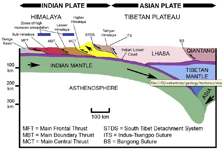
c) Page 261: Ref: Himalaya. Here is how Pranay Lal describes the rise of the Himalaya. "
The Himalaya rose from below. The rubbing together of the immense plates and the monumental crushing and buckling of land produced a tremendous amount of heat and cause magma from below to ooze out of deep fissures which opened up on the surface. This melted and remelted granite, and pushed it upwards to the surface. As the granite slowly cooled, successive batches of molten granite thrust their way up,forcing the older granite slabs higher. Over time, this process created a pedestal for mountain building. Because the "cooking" process varied (different types of granite are cooked at various depths), the densities of rock slabs differed. This created large cracks or "faults" along places where the continental crust rasped, grinded and pushed slowly onward".
I didn't understand this at all.
Later he says that the Everest is made up of an initial four thousand odd meter foundation of granite overlain by another 3100 meter of sedimentary rock. The granite is 50-30 million years old while the sedimentary rocks are from the Paleozoic era (359 - 252 million years old).
During continental collision, there has been melting of the lower parts of the crust and this terrain has been intruded by pods and lenses of younger granite. Metamorphosed and partially melted Precambrian rock is the main component of the Greater Himalaya. In the Everest -Lhotse-Nuptsu region the granite intrusions are on a massive scale as described by Pranay Lal. These thick intrusive granite and high grade metamorphic rocks make up the base of Everest region. But, these younger granite intrusions are not this thick everywhere. They are present on a smaller scale along certain bands of the Greater Himalaya and are almost absent from the Lesser Himalaya.
Though the author may not mean it, phrases like "
successive batches of molten granite thrust their way up, forcing the older granite slabs higher" may be misinterpreted by lay readers to mean that Himalayas formed as a result of magma pushing the crust up to form mountains. This is not how orogenic mountains like the Himalaya form.
As the Indian Plate collided with Asia it delaminated. You can think of this as the plate splitting into two tiers. The lower tier comprising the lower crust and upper mantle slid under Tibet. The upper tier impinged into Tibet and got squeezed, deformed and thickened. The Himalaya is this folded and faulted upper tier. The different Himalayan ranges are slices of the upper tier Indian crust stacked one on top of the other by a series of south moving thrust faults.
The tectonic structure of the Himalaya with its geological divisions is summarized in the graphic below.
Source:
Shankar Chatterjee et. al. 2013
What was the sequence of these thrust faulting events and how do they fit into the three pulses of mountain building that Pranay Lal mentions?
Leaving the Tibet part aside, the Himalaya most people are familiar with are made up of four distinct geological terrains. I am listing them starting from the north and going south. Tethyan sedimentary rocks (the ones making up the Everest and many other summits; These sediments range in age from the Neoproterozoic to the Eocene- ~ 1000 million years to 40 million years, although the entire sequence is not exposed at one place), the Greater Himalaya Crystalline Complex (Proterozoic to Early Paleozoic, 1800 million years to 480 million years, with a younger imprint of metamorphism and granite intrusions), the Lesser Himalaya Sequence (Proterozoic to Cambrian; gneiss and low grade metamorphosed sediments, 1850 million years to 520 million years) and the Siwaliks which are Cenozoic sedimentary rocks deposited from around 15 million years to about 0.5 million year ago. The geological divisions roughly match up with the topographic divisions of the Greater Himalaya, the Lesser or Middle Himalaya and the Outer or Sub Himalaya.
The northern edge of the Indian plate was made up of Proterozoic rocks, much as it is all across Peninsular India. This Proterozoic sequence was overlain by Paleozoic and Mesozoic sedimentary rocks. There is a more complete sequence of Paleozoic sediments in the Himalaya, since even though most of India was landlocked as part of Gondwanaland, the north edge of what was to become India was open to the Tethys sea all through the Paleozoic and Mesozoic.
As India collided with Asia:
1) Its continental crust impinged on the continental crust of Asia. The Neoproterozoic-Phanerozoic sedimentary cover was folded, faulted and scraped off and uplifted to form an early mountain range made up of the Tethyan sediments.
2) Horizontal shortening of the Indian crust during collision led to crustal thickening and rocks were subjected to high temperatures and pressures. They were metamorposed and partially melted into rocks known as migmatites and intruded by granites. Finally, compressive stresses broke the crust along a major fault known as the Main Central Thrust and uplifted this deeply buried terrain. The thrust moved crustal blocks upwards and southwards. Some geologists believe that the Great Himalaya Crystalline Complex is made up of hot soft rocks from the middle regions of the Indian crust which flowed towards the surface in response to the removal of crustal cover by erosion. This ductile flow of rock from deep in the crust towards the surface is termed "channel flow" as hot soft rock is confined to a layer or channel between colder upper crust and a more rigid upper mantle.
Either way, with this thrusting and extrusion of high grade rock began the formation of the Greater Himalaya. The main activity of the Main Central Thrust is dated to between 16 million years to 25 million years or so. At about the same time the earlier uplifted Tethyan sediment detached themselves from the underlying crystalline basement and started sliding northwards along a major fault system known as the Southern Tibetan Detachment System.
3) As India continued to press into Asia, compressive stresses propagated southwards. Beginning around 16 million years to 11 million years, the terrain to the south of the Main Central Thrust began to get folded and faulted. Since it was further to the south from the collision zone, it did not experience the high levels of metamorphism and granite intrusions that the rocks of the Great Himalaya did. Eventually, these more distal rock formations were uplifted and moved southwards along the Main Boundary Thrust and associated faults to form the Lesser Himalaya.
4) The rise of the Greater Himalaya and the Lesser Himalaya loaded and depressed the crust in front of them in to a moat. In the alluvial plains, streams and lakes that formed were deposited sediments eroding from the rising Greater and Lesser Himalaya. These were the environments in which a lot of the mammalian evolution and diversification described in an earlier chapter took place. Beginning around a million years ago, maybe a little earlier, these sediments were folded, uplifted and thrust above the Gangetic alluvium along the Main Frontal Thrust to form the Siwalik ranges. The Main Frontal Thrust is still active, and Himalaya earthquakes which originate deep underground rupture along this fault plane. The Himalaya are growing southwards.
I am not writing a popular book for the lay public. I realize I may have gone overboard with my Himalaya explanation and am not suggesting that Pranay Lal should include all this in his book. But any explanation should include at least the basic arrangement of the different lithologic terrains and their sequential uplift due to south progressing thrust faulting.
d) Page 218 - Ref: Satpura mountains were uplifted due to the rise and push of magma leading up to the Deccan volcanism.- This is also a longer discussion but I'll stop on the geology aspects since this post is already too long. Let me refer to an
article on the lack of pre- Deccan volcanic uplift in the Satpura region and elsewhere. Many geologists have concluded that the uplift of the Satpura belt is not due to the push of magma. It occurred much later in the Cenozoic due to the various stresses on the Peninusular Indian crust.
e) I couldn't help elaborating on this: Why do animals grow large? Pranay Lal mentions an intriguing evolutionary pattern seen in the fossil record. There is a trend towards an increase in body size in the early to mid Triassic following the Permian mass extinction. A second trend in increase in body size in seen in the Cretaceous when some lineages of dinosaurs evolved gigantism. The explanation given is that an increase in atmospheric oxygen levels favored an increase in body size.
Animals have a physiologically demanding lifestyle. That a certain threshold of oxygen will be required for them to prosper over the longer term is a given. It is too broad an explanation and it doesn't tell us why in a group one lineage evolved towards a larger size while a related lineage did not. In the two time periods that author points to, the reason why species evolved towards large size in the Triassic immediately after the Perman mass extinction may be different from why certain lineages evolved gigantism in the Cretaceous.
Let's take the case of body size trends during the early Triassic. Mass extinctions disproportionately cull larger bodied species . Since environmental condition are deteriorating rapidly, larger bodied species with more energy expensive demands and slower reproduction rates cannot cope as well as species with a smaller body size. Survivor species in the aftermath of mass extinctions are small bodied, maybe as small as their biological limits. From this starting point, even if environmental conditions in the post mass extinction period are neutral in terms of favoring species with a particular body size, the only trend that will emerge is one towards a larger body size, since there is no room to get any smaller.
For Cretaceous too the oxygen hypothesis seems too pat. I could argue that Cretaceous was a time of high carbon dioxide levels. That would mean more food for plants. A lush healthy vegetated landscape means more food for herbivores, conditions favorable for evolution of larger size. Again this is a "just so story".
Why did gigantism evolve in the Sauropoda? The answers may lie in phylogenetic heritage i.e. inheritance of ancestral characters which fortuitously proved advantageous, and evolutionary innovations that enabled them to acquire and utilize resources more efficiently than other groups. An avian style respiratory system enabled pnematization (air cavities in bones) of the axial skeleton. This evolved early in Sauropod history. A small head evolved because food was ingested without mastication. These two features enable a long neck to evolve (lighter head, lighter skeleton). A long neck enabled access to food not available to other herbivores.. a cascade of benefits due to inherited and newly acquired features.
Off course, these are ramblings about things that interest me. I have no expectation that Pranay Lal put all these details in his book.
But, we need books like these to fire imaginations and inspire amateurs and students to go out and explore India's rich physical landscape. A good place to start will be the
National Geological Monuments listed by the Geological Survey of India. A surge of visitor interest might put pressure on the government to expand protection to more sites of interest. The destruction of irreplaceable fossil sites and geological structures is a constant theme in Lal's book.
A second edition of this book will be welcome, but one that has gone scrutiny by a discerning geologist editor.