Tuesday, June 20, 2017

Quiz: Spot The Granite Intrusion

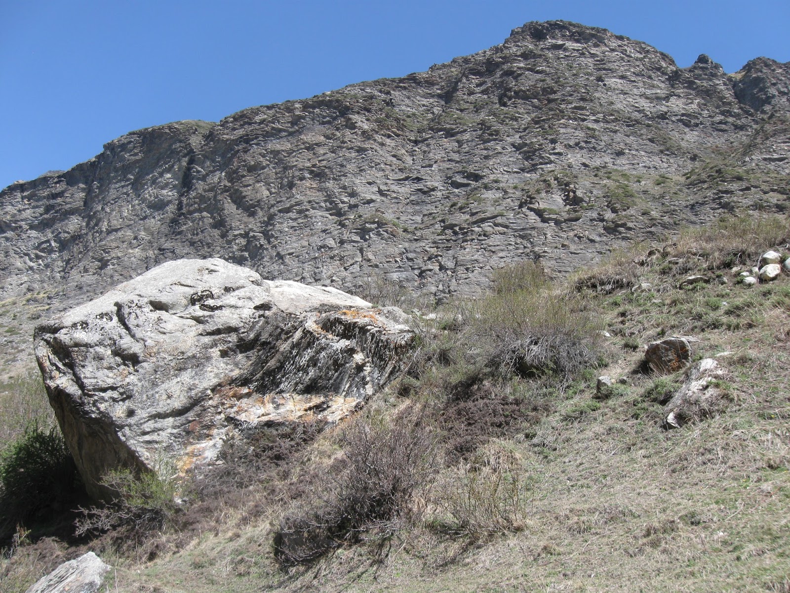
I came across this glacially transported boulder in the Dugtu village valley near the Panchachuli Glacier in the Kumaon Himalaya.

It is a block of high grade gneiss intruded by a granite. Without scrolling beyond the first photograph, try to work out the contact between the gneiss and the granite.


Answer:

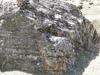
The boulder is encrusted by moss. There is some mineral staining too. And sunlight falling on the rock gives it a speckled appearance.. All this reduces the contrast in color between the gneiss and the granite.

But there is a vital clue in the orientation of structures. Both the gneiss and the granite have a planar fabric imprinted on them.

The fabric of the gneiss is due to the orientation of platy minerals like micas stacked in layers, alternating with layers richer in quartz and feldspars. Assume this is the original disposition of the rock as well. The gneiss layering you see is due to the trace of horizontal planes of separation of different mineral layers. I have outlined some of this planar fabric in brown lines.

The granite has a planar fabric too, but this is due to near vertical fractures. The rock has been broken in to thin slabs  by fractures (red lines) which may have formed during the cooling of the magma. These fractures don't pass into the surrounding host gneiss. Two arms of the granite have penetrated between the gneiss layers forming mini sills.

You can see the contact (black line) between the gneiss and the granite roughly where my wallet is. Here, the horizontal planar fabric of the gneiss abruptly juxtaposes against the vertical planar fabric of the granite.


Thursday, June 15, 2017

Field Photo: Glacial Erratic

Inspired by this xkcd comic:


I saw quite a few of these glacial erratics in the Dhauliganga river valley around the villages of Dugtu and Dantu. Here is my friend sitting on one of them.


This boulder is a high grade gneiss. It is an erratic because the surrounding bedrock is all low grade phyllite and slate. The source of the high grade gneiss boulder is the snow capped range you see in the background. These are the Panchachuli peaks and the Panchachuli glacier has eroded, transported and deposited gneiss rocks all the way down the valley onto a different bedrock.

The photo below shows another erratic from this valley. If you look closely it is a mixed rock made up of high grade gneiss intruded by light colored granite. A big patch of dark grey banded gneiss is visible in the lower right corner of the boulder. The cliffs in the background and the substrate on which the boulder rests is low grade phyllite.


And a long view of village Dugtu with glacial erratics strewn all over the hill slope (blue arrows).


I have been promising a post on the glacial deposits of the Dhauliganga river valley. That post will come soon. Meanwhile, here is a view of some of the moraines I saw near village Dugtu.  Photo taken from near the snout of the glacier facing downstream.


The linear ridge in the center of the photo made up of rust, brown and light colored boulders is a medial moraine. It was formed when two glacial streams carrying debris along their edges joined. As these glaciers receded the debris along their edges (lateral moraines) coalesced and formed a ridge in the center of the valley. You can see the milky white colored Dhauliganga river flowing to the right of the ridge. The blue arrows to the right of the picture high up along the mountain slopes point to older lateral moraines deposited when the Panchachuli glacier was thicker and extended further down in the valley...

more on these deposits later..

Tuesday, June 13, 2017

Books: Origins Of Complexity ; China Water History

These just arrived.

Extract:

I hope to persuade you that energy is central to evolution, that we can only understand the properties of life if we bring energy into the equation..... I want to show you that the origin of life was driven by energy flux, that proton gradients were central to the emergence of cells, and that their use constrained the structure of both bacteria and archaea. I want to demonstrate that these constraints dominated the later evolution of cells, keeping the bacteria and archaea forever simple in morphology, despite their biochemical virtuosity. I want to prove that a rare event, an endosymbiosis in which one bacterium got inside an archaeon, broke those constraints, enabling the evolution of vastly more complex cells. .....Finally, I want to convince you that thinking in these energetic terms allows us to predict aspects of our own biology, notably a deep evolutionary trade-off between fertility and fitness in youth, on the one hand, and ageing and disease on the other.

The last book I read on the evolution of complexity was Mark Ridley's The Cooperative Gene which described the many evolutionary inventions that suppress genomic conflict and make multicellular bodies workable. Nike Lane writes at a more fundamental level of the energy currency of the cell. Feeling very excited about this book. I am sure to learn a lot.

Extract:

But the ubiquitous and ambivalent relationship that the Chinese people have had with water has made it a powerful and versatile metaphor for philosophical thought and artistic expression, and its political connotations can be subverted and manipulated in subtle ways for the purposes and protest and dissent. These meanings of water are more than metaphorical. Because the lives of everyday folk has always depended on water, the river and canals mediate their relationship to the state. Water -too much of it,or too little - has incited the people to rise up and overthrow their governments and emperors. Burgeoning economic growth now places unprecedented pressure on the integrity and sometimes the very existence of China's waterways and lakes. Not only can China's leaders ill afford to ignore this potential brake on economic growth, but the environmental problems are leading to more political pluralism in a nominally one party state.

Sweeping... from the Qin Dynasty (200 B.C.) to the present..

Thursday, June 1, 2017

The Serpents Of Nagling- Granite Intrusions Into Greater Himalayan Sequence Metamorphics

Over chai, elders told us about large serpents invading their village. A curse, they said. Only the correct prayers and purification rituals saved them, forcing the serpents to retreat deep into the forest. Some serpents remain trapped in the rock faces near the village, which was renamed Nagling (Nag means cobra..or more generically serpent).

The picture below are the entombed serpents of Nagling (trekkers for scale).


Geologists recognize them to be granite dykes (intrusions cutting across host rock layering) and sills (intrusions parallel to host rock layering) intruding the high grade metamorphic rocks of the Greater Himalayan Sequence (GHS).

The GHS is a block of the Indian crust bounded between the Main Central Thrust (MCT) at the base and the South Tibetan Detachment System (STDS) at the top. It represents mid crustal material which was metamorphosed and then was extruded and exhumed during Himalayan orogeny between 25 million years ago to about 16 million years ago. These dates vary somewhat along the strike of the Himalaya. Thrusting along the MCT took place earlier in the western Himalaya. Eastern regions like the Sikkim Himalaya record younger dates for the movement of the MCT.

The grade of metamorphic varies within the GHS. The figure below is a schematic section of the Greater Himalayan Sequence. It is from a study on the nature of the MCT by Michael Searle and colleagues from the Nepal Himalaya and is a very useful guide to think about the internal structure of the GHS.


 Source: Searle et. al. 2008

From the base of the MCT the grade of metamorphism increases towards higher structural levels. This is recognized as an "inverted metamorphic gradient", since minerals that are formed at higher and higher temperatures and pressures are occurring at structurally higher and by implication apparently shallower levels of the crust. The inverted gradient is recognized by the successive appearance of  biotite, garnet, sillimanite and finally kyanite. The sillimanite-kyanite zone transitions into the zone of partial melting and granite intrusives. This is the zone where the crust experienced conditions that lead to the formation of in situ melts and their mobilization and intrusion into surrounding rock. Above this zone the grade of metamorphism reduces towards the STDS. In the figure, the granite intrusion zone is directly overlain by the STDS and the Tethyan sequence. However, there is variation in this theme across the Himalaya. In the Kumaon region where I was, the "melt zone" is overlain by a sequence of lower metamorphic grade phyllite rocks.

What caused this melting and production of granitic magma? Many geologist point to the STDS. They suggest that this zone of extentional faulting stretched and thinned the crust, resulting in " decompression-related anatexis". This means that when extentional faulting along the STDS and exhumation reduced the overburden on deeply buried hot rocks, the release in pressure resulted in the lowering of rock melting point. This led to a partial melting of the crust (anatexis). Other geologists disagree with this explanation. They point out that since decompression has a minor effect on melting the likely source rock compositions you would require unreasonably large amounts of denudation along the STDS.  Rather, they suggest that crustal thickening by the continued convergence of India with Asia elevated temperatures in the middle levels of the crust to a range where partial melting began. These melts then moved along weak planes and intruded the surrounding GHS above the sillimanite and kyanite grade gneisses. The main pulses of this magma generation took place between 24 million years and 19 million years ago.

Geologists estimate the temperatures of this melt zone to be around 650 deg C to 750 deg C, corresponding to a  burial depth of about 20-25 km. Yes, the GHS represents crust that has traveled from that depth to the Himalayan heights it now commands by a combination of thrust faulting and erosional unroofing i.e. the stripping away of shallower levels of the crust!

During one of my previous treks in the Kumaon region I had walked across the GHS from the base of the MCT to the sillimanite zone in the Goriganga valley from the town of Munsiari to village Paton. This time, one valley to the east,  we began our trek at village Nagling in the zone of  partially melting. All around us were rock faces intruded by sill complexes and dykes. The picture below shows multiple sills of granite cross cut by dykes.


High up from Nagling village towards Nagling Glacier I saw this granite dyke complex (outlined by red dotted lines ) cutting across metamorphic banding (black lines).


And in the stream near Nagling Glacier I came across this rounded stream boulder showing granite cross-cutting banded migmatitic gneiss.


We traveled north and  reached Duktu. Earlier, somewhere near the village of Baaling, we had crossed the zone of partial melting and were in the uppermost levels of the GHS made up of phyllite grade metamorphic rocks. The phyllites are not intruded by granite.

However, granite was present at Dugtu too, but only in the Dhauliganga river bed. This river emerges from the Panchachuli Glacier. The Panchachuli ranges which fall lower in the GHS are made up of high grade gneiss intruded by granite.

As a result, the Dhauliganga river bed near Duktu village is choked with boulders of granite and migmatite rocks.


This is a very distinctive  biotite-tourmaline granite. The picture below shows blocks of granite with tabular black tourmaline.


Here is a picture of me looking intently at a block of GHS made up of a granite intruding in to a gneiss.


And another close up of light colored granite intruding dark grey banded gneiss and encircling and enclosing rafts of the metamorphic host rock (red arrows).


And finally, from the sheer rock faces near Nagling Glacier, one of my favorite examples of the granite intrusions. A near vertical dyke (red broken outline) cut and displaced by a fault (yellow broken lines). Metamorphic banding shown in black lines.


... Pleistocene-Holocene glacial deposits of the Panchachuli Glacier area.. coming up next!