Monday, June 20, 2016

Nepal Earthquake Aftermath- What Is Happening Underneath Kathmandu?

We continue to learn more about the buildup and release of strain along the master detachment fault underneath the Himalaya. The master detachment fault known as the Main Himalayan Thrust is the surface along which the Indian plate is sliding underneath Asia.

This data using GPS records of surface motion in the area affected by the 2015 Gorkha (Nepal) earthquake:

Himalayan strain reservoir inferred from limited afterslip following the Gorkha earthquake -David Mencin et al 2016 (behind paywall)

The magnitude 7.8 Gorkha earthquake in April 2015 ruptured a 150-km-long section of the Himalayan décollement terminating close to Kathmandu. The earthquake failed to rupture the surface Himalayan frontal thrusts and raised concern that a future Mw ≤ 7.3 earthquake could break the unruptured region to the south and west of Kathmandu. Here we use GPS records of surface motions to show that no aseismic slip occurred on the ruptured fault plane in the six months immediately following the earthquake. We find that although 70 mm of afterslip occurred locally north of the rupture, fewer than 25 mm of afterslip occurred in a narrow zone to the south. Rapid initial afterslip north of the rupture was largely complete in six months, releasing aseismic-moment equivalent to a Mw 7.1 earthquake. Historical earthquakes in 1803, 1833, 1905 and 1947 also failed to rupture the Himalayan frontal faults, and were not followed by large earthquakes to their south. This implies that significant relict heterogeneous strain prevails throughout the Main Himalayan Thrust. The considerable slip during great Himalayan earthquakes may be due in part to great earthquakes tapping reservoirs of residual strain inherited from former partial ruptures of the Main Himalayan Thrust.

The Himalaya cross section below shows seismicity along the interface of the Indian plate boundary faults.  MFT is the Main Frontal Thrust, MBT is the Main Boundary Thrust and MCT is the Main Central Thrust. These south younging sequence of thrust faults are thought to absorb the crustal shortening in the Himalayas. The youngest, the Main Frontal Thrust is thought to be active today, i.e. great earthquakes that nucleate underneath the Himalaya, rupture the surface along this fault system. All these thrusts faults are inferred to be splays of the Main Himalayan Thrust. Red and Orange dots are instrumentally recorded earthquakes.


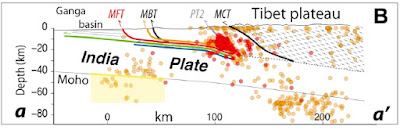
Source: Bollinger et al 2014: Estimating the return times of great Himalayan earthquakes in eastern Nepal: Evidence from the Patu and Bardibas strands of the Main Frontal Thrust

Monday, June 13, 2016

The Unconformity At Rathivade

My friend Pradeep Sarkar died last Tuesday June 7th. He got up that morning and complained of shortness of breath. In a few minutes it was all over. He leaves behind a shattered family, a wife and a son, and a large number of stunned friends, colleagues and students.

I met Pradeep when he joined the faculty at Fergusson College, Pune, during my second year B.Sc. He had a way with students and his enthusiasm for geology rubbed on to others. A boring summer vacation was looming ahead.  Having already decided to major in geology, Anil Lalla, Nalin Nair and myself asked him if he was going for fieldwork to the Konkan coast. As it happened he was and to our delight he invited us to go along with him.

We traveled to the little town of Malvan in the Sindhudurg district in southern Maharashtra. His research involved mapping the Precambrian geology with emphasis on understanding sedimentary structures and environments of deposition of the mid-late Proterozoic Kaladgi Group. Peninsular Gneiss, Greenstone schist belt, deformed conglomerate, trough cross bedding, fining up sequence. We had read and heard about these magical geological features in class. Pradeep made them come alive in the field in the week of our arriving at Malvan. He taught us how to read a toposheet and how to overlay the geology on it. He taught us how to measure and describe lithological sections. He taught us how to scan the horizon and see beyond.

In the evenings after fieldwork we used to go to the rocky  Malvan beach where the Kaladgi Group sediments were exposed. He used to point out to us ripple marks and bedforms made by the action of waves on a sandy sea floor more than a billion years ago. Sometimes we walked a little out of the way, outside town, to one of his favorite spots. A bridge over a small estuary; there we stood watching the rise or ebb of tides, taking in the salty breeze, waiting for the Arabian Sea sunset. Malvan would remain very close to his heart long after he finished his PhD work. He ended up marrying a local girl, the daughter of the lodge he always stayed in.

We remained good friends throughout. After I left India to pursue graduate studies we struck up a lively correspondence. I used to mail him research papers. His interests were moving toward studying calcrete, calcium carbonate deposits found as nodules and veins in the semi arid eastern Deccan plateau. On my return to India a few years back we renewed our meetings. During short chai sessions at the local tapri he used to hold court, talking excitedly of his research and teaching commitments. He wanted to see some of my PhD samples of Ordovician carbonates and maybe hold a lab session with graduate students. I agreed to meet him in his lab. Alas, that day never came. His work load was such that he just never got around organizing it.

Last week on June 10th I attended a sad but memorable condolence meeting for Pradeep. Friends and colleagues talked touchingly on the many memories they had of time spent with him. He leaves behind a legacy of 3 decades of excellence in teaching and of inspiring countless students to take up geology as a career.

When I heard the news of his passing on June 7th, my mind skipped back to that field trip and I found myself thinking about the unconformity near the village of Rathivade some distance away from Malvan. Amidst monsoon showers and sunny interludes we walked through the Konkan countryside. In a stream bed we came across something he had badly wanted us to see- The Great Eparchaean Unconformity. There scattered along were patches of Archean gneiss. Along the stream bank overlying the gneiss were mid Proterozoic Kaladgi sediments. By the time I had walked to the stream edge, Pradeep had rushed in and was already standing knee deep in water. It is an important feature of Indian geology he explained.... this unconformity. Etched on the surface of Peninsular India, it speaks of a change from a hot tectonically active Archean earth in which was formed the gneiss, to a cooler more stable Proterozoic world, where, on large cratonic basins in shallow seas, thick sequences of sandstones and limestones accumulated. This unconformity- he told us-  marks a long period of quiescence between these two phases of formation of the earth's crust, maybe a 300 -500 million year break.

With amazement we stared at him. 

Since then, at different times and places, I met and was influenced by other good teachers and mentors who kept my interest in geology alive. But it all began during that late summer in June 1986 when the generosity of a young PhD scholar opened the eyes of three geology enthusiasts to the wonders of this earth.

 Pradeep Sarkar 1960-2016

Monday, June 6, 2016

Quote: David Quammen On Continental Versus Oceanic Islands

I have been writing on the geological origins of India's two famous island chains. Coincidentally, I am reading  David Quammen's classic book - The Song Of The Dodo- Island Biogeography In An Age Of Extinctions. The focus is about the importance of islands in understanding evolution and extinction. Darwin and Wallace independently got their insights regarding the formation of new species through studying the geographic distribution of fauna on island groups.

Yesterday being World Environment Day it is timely to share this great passage-

A continental island begins with everything, and everything to lose. An oceanic island begins with nothing and everything to gain. Island biogeography, over the past century and a half, has been the scientific record of those gains and losses. 

What this implies is that since continental islands are extensions of continents with a low area between them and the main landmass, they already have a terrestrial fauna on them when they become isolated on account of rising seas flooding the low shelf and severing the land connection between. Oceanic islands on the other hand rise from the ocean floor anew, made up either of lava piling up from the sea floor,  or by coral growth on undersea volcanic summits. They get colonized by birds flying in from the mainland an reptiles and small mammals arriving with flotsam. These are pioneer fauna which diversify in their unique way on this new land.

Highly Recommended.

Thursday, June 2, 2016

The Theory Of The Glacial Sarasvati Has Been Given A Quiet Burial

Something significant went unnoticed and unreported amongst all the hoopla surrounding the recent paper on Harappan civilization and its link to climate change. The theory of the glacial Sarasvati got dumped. The paper does not even mention it as a possible reason for the reduced water flow in the Ghaggar. Based on its geographic description in the Rig Ved the Ghaggar has been equated with the Vedic Sarasvati river.

The glacial river theory proposed that the river Yamuna and the river Sutlej, both glacially sourced from the high Himalaya,  earlier flowed into the Ghaggar. They changed course around 2000 B.C or so to their present day channels. This switch starved the Ghaggar of water and it became a smaller ephemeral river. This theory also accepts that climate change did occur, but the main reason for the apparently sudden water shortage was the changing of course of the glacial rivers.

Until a few years ago, there just wasn't enough detailed work done on the sediment provenance (comparing characteristics of old channel sands of Ghaggar with those of present day Yamuna and Sutlej) and channel chronology of the Ghaggar system to say whether this theory was correct. But work  published in 2012 on river sediment provenance tied to a chronology and analysis of fluvial landforms have shown that the Yamuna and Sutlej did once flow into the Ghaggar but changed course to their present locations by late Pleistocene-earliest Holocene, thousands of years before the Harappan civilization. Since this work, no new data challenging these results has appeared. Scientists as evidenced by this paper appear to now accept that the Ghaggar was a monsoonal river right through the Holocene.

This result has annoyed not only geologists who had proposed the glacial river theory but also supporters of the indigenous Aryan theory. They had used the glacial river theory to time the presence of the Vedic people in the plains of Haryana and Punjab before 2000 B.C. The reasoning was that the Rig Ved describes a mighty Sarasvati flowing down from the mountains. Hence, it must have been glacially sourced and must have been the present day Ghaggar. The Aryans would have had to have been present in northwest India before the river became less mighty i.e. before 2000 B.C. This according to them destroyed the Aryan Invasion /Migration theory which proposed that the Aryans, who were a Central Asian people, entered India after the Harappan civilization disintegrated.

Where do we stand now in terms of the Aryan question in the light of the new results on the Ghaggar river?

Well, in exactly the same place as before! It was always futile to try to link the condition of the river, whether glacial or monsoonal to the question of the origin of the Aryans. The Rig Ved describes a big river. It doesn't really say that it was glacial in origin. If the Aryans had been present in the Punjab and Haryana before around 2000-1800 B.C. they would have seen a larger Ghaggar (due to a wetter climate).

At the same time, this supposed earlier presence of the Aryans in the Harappan realm does not automatically answer the question of their origins. They just as well could have represented an earlier wave of Central Asian migrants who settled in northwest India during the latter stages of the Harappan civilization. For this same reason, the indigenous Aryan theory would not have been strengthened even if the river had turned out to be glacial during Harappan times.

The geological history of the river cannot solve this riddle. A combination of archaeology, deciphering the script and genetics will be required. We await with anticipation the results of the DNA recovered from Harappa age skeletons.

In the meantime, people who tend to read too much into Rig Vedic hymns should accept that the Vedic poets who wrote (source) -

"This (Sarasvati river) has shattered mountain peaks with her fast and powerful waves, just (as easily) as one uproots the lotus-stems, let us invoke her,who strikes what is far and near, with holy hymns and prayers"..

and ..

"Whose boundless, impetuous and swift-moving flood gushes forth with a tempestuous roar"

may have been really looking at a brown colored muddy, silty, sluggish river originating in the Siwalik hills.

Put that down to poetic license!