
This has been pending. As I posted earlier this month I returned from a trek in the Kumaon Himalayas along the Ramganga river in the Namik Valley just west of the town of Munsiyari in Pittorgarh district. The terrain is mostly the Lesser Himalayas made up of the Lesser Himalayan Sequence (LHS) composed of late Proterozoic to early Palaeozoic metasediments.
The red line on the map below shows my location with respect to the regional Lesser Himalayan structure and stratigraphy.

Source: Celerier et. al. 2009
A quick recap of the geology:
1) A paleogeographic division of the LHS into an inner LHS and an outer LHS is recognized. Inner LHS refers to sediments deposited nearer the Indian craton while outer LHS refer to sediment sequences deposited further in the open shelf and slope away from the Indian craton.
2) In outcrop the outer LHS is exposed closer to the India craton while the inner LHS is exposed away from the India craton. This is due to a south directed Tons Thrust (Miocene?) which brought the outer LHS over the inner LHS. Subsequent erosion of the Tons hanging wall has exposed the inner LHS in a more northerly location.
3) The south directed Main Central Thrust (known as the Munsiyari Thrust locally) brought medium to high grade metamorphics of the Greater Himalayan Crystalline Series over the LHS. This resulted in thermal metamorphism of the LHS in the Miocene and Pliocene.
4) As Himalayan orogeny continued during the Mio-Pliocene the inner LHS was fed in to the deforming pile. The inner LHS was broken up along the Berinag Thrust which brought older inner LHS Berinag Formation over younger inner LHS Deobang Formation. The Berinag Thrust was folded in an anticlinorium. Erosion of the hanging wall has created thrust windows exposing footwall Deobang Formation in the core of the anticline. Some recent thermochronology analysis along the Munsiyari Thrust and the Berinag Thrust in this region suggest fault activity continuing in the Plio-Pleistocene.
So the structural geology and stratigraphy of the area I was in i.e. along the Ramganga River near the villages of Shama and Gogina is controlled by the Berinag Thrust and to the north by the Munsiyari Thrust (also spelt Munsiari Thrust in recent geology literature).
The interactive map below shows the location of the Berinag Thrust and the Munsiari Thrust and has descriptions of the footwall and hanging wall lithologies.
View Berinag and Munsiari Thrust Faults Shama Gogina Road in a larger map
I could recognize these features as I travelled along the road from village Shama to village Gogina. I started at village Shama which is in the erosional window of the Berinag Thrust and exposes footwall Deobang Formation dolomites. The Berinag Thrust was observed at milepost Gogina 15 km. It is a south directed northeasterly dipping thrust fault. The fault zone is a few tens of meters thick. Footwall lithology is Deobang Formation dolomites and graphitic phyllite. Hanging wall lithology is Berinag Formation quartzites. Both the footwall and hanging wall lithology in the immediate vicinity of the fault zone have been sheared and mylonitized.
Below is a view of the Berinag Thrust looking in an easterly direction.

Northwards towards Gogina I noticed signs of increased shear strain in Berinag Formation quartzites. The quartzite is intruded by ptygmatically folded quartz veins, has a pronounced foliation imparted by bands of muscovite and biotite and there are occasional lenses of biotite augen gneiss. This was an expected observation as the Berinag Thrust is structurally immediately below the Munsiari Thrust (Main Central Thrust 1).
The Main Central Thrust (MCT) is recognized as the most important structure of Himalayan mountain development. It brings into structural contact the Greater Himalayan Crystalline series over the LHS. The MCT is a wide fault zone and it has several fault strands. The lower and upper bounding faults of the MCT zone are called MCT 1 and MCT II respectively. This is the terminology recognized for the Nepal Himalayas. In the Kumaon region the MCT 1 has been equated with the Munsiari Thrust while the MCT II is called the Vaikrita Thrust. One interpretation of the Munsiari Thrust is that it is a fault in an imbrication zone at the footwall of the Vaikrita Thrust and incorporates sediment of the LHS along with the Greater Himalayan Crystallines. Along with lithology, generally geologists have used strain criteria and increased metamorphic grade towards the Vaikrita Thrust to identify the lower and upper boundaries of MCT. On the basis of this, the Munsiari Thrust is defined as the base of a broad ductile shear zone ( a zone characterized by ductile deformation fabrics).
The rocks between the Munsiari Thrust and the Vaikrita Thrust are amphibolite grade metamorphics while the rocks above the Vaikrita Thrust (hanging wall) are medium to high grade metamorphics. These are termed the Munsiari Formation and the Vaikrita Formation respectively although there are other local terms for them. For example, a Geological Survey of India (GSI) mapping report of the Ramganga valley area terms the Munsiari Formation as the Helang Formation.
The Greater Himalayan Crystalline series is a medium to high grade metamorphic terrain representing leading edge of the Indian cratonic basement plus Late Proterozoic to Early Paleozoic sediments and intrusives either formed in a separate basin on the Indian shelf or belonging to an exotic terrain which accreted onto the Indian craton sometime in the Paleozoic or according to an astonishing new theory (see this Metageologist post) may be mid crustal material of the Asian plate which has flowed southwards (not in a liquid form; this refers to crustal flow of a hot plastic material) during Himalayan crustal thickening and at a shallower crustal level been juxtaposed along the MCT over the LHS.
Anyways, I was excitedly looking to recognize the lower bounding fault of the MCT i.e. the Munsiari Thrust. The general field criteria is a change of metamorphic grade from low grade metamorphic to medium grade metamorphic and the increased presence of shear strain structures like mylonites and asymmetric augen. I saw this transition just ahead of milepost Keti 3 km (Gogina 8 km). Here the foliated Berinag Formation quartzites were overlain by a thick section of biotite schists and augen gneiss. Northwards along the road I did not observe the Berinag Formation lithology again. So I have tentatively recognized the lithologic transition at milepost Keti 3 km as the sole of the Munsiari Thrust.
The image below shows the location of the change in lithology from Berinag quartzite to medium grade schists and gneisses.

As we neared Gogina the lithology was layers of biotite schist, augen gneiss and amphibolites all intruded by quartz veins. I was well within the Main Central Thrust zone. Somewhere northwards of Gogina is the upper bounding fault of the MCT zone which is Vaikrita Thrust, but we did not go that north. My traverse stopped at the village of Gogina in the hanging wall of the Munsiari Thrust (MCT 1).
A few more pictures of the Lesser Himalayan Sequence and Main Central Thrust zone lithologies:
Berinag Formation quartzites just north of the Berinag Thrust fault zone.

An outcrop of medium grade schist and augen gneiss in the Munsiari Thrust hanging wall (MCT fault zone)

Close up of biotite augen gneiss from the MCT fault zone.

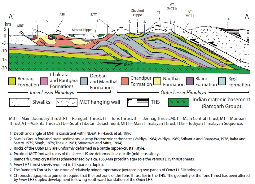
Finally, a more complete picture to the reader is given by the cross section below of the Kumaon Himalayas which shows the stratigraphy, thrust faults and erosional windows and klippen resulting in the exposure pattern we observe today.

Source: Celerier et. al. 2009
The red line on the map below shows my location with respect to the regional Lesser Himalayan structure and stratigraphy.
Source: Celerier et. al. 2009
A quick recap of the geology:
1) A paleogeographic division of the LHS into an inner LHS and an outer LHS is recognized. Inner LHS refers to sediments deposited nearer the Indian craton while outer LHS refer to sediment sequences deposited further in the open shelf and slope away from the Indian craton.
2) In outcrop the outer LHS is exposed closer to the India craton while the inner LHS is exposed away from the India craton. This is due to a south directed Tons Thrust (Miocene?) which brought the outer LHS over the inner LHS. Subsequent erosion of the Tons hanging wall has exposed the inner LHS in a more northerly location.
3) The south directed Main Central Thrust (known as the Munsiyari Thrust locally) brought medium to high grade metamorphics of the Greater Himalayan Crystalline Series over the LHS. This resulted in thermal metamorphism of the LHS in the Miocene and Pliocene.
4) As Himalayan orogeny continued during the Mio-Pliocene the inner LHS was fed in to the deforming pile. The inner LHS was broken up along the Berinag Thrust which brought older inner LHS Berinag Formation over younger inner LHS Deobang Formation. The Berinag Thrust was folded in an anticlinorium. Erosion of the hanging wall has created thrust windows exposing footwall Deobang Formation in the core of the anticline. Some recent thermochronology analysis along the Munsiyari Thrust and the Berinag Thrust in this region suggest fault activity continuing in the Plio-Pleistocene.
So the structural geology and stratigraphy of the area I was in i.e. along the Ramganga River near the villages of Shama and Gogina is controlled by the Berinag Thrust and to the north by the Munsiyari Thrust (also spelt Munsiari Thrust in recent geology literature).
The interactive map below shows the location of the Berinag Thrust and the Munsiari Thrust and has descriptions of the footwall and hanging wall lithologies.
View Berinag and Munsiari Thrust Faults Shama Gogina Road in a larger map
I could recognize these features as I travelled along the road from village Shama to village Gogina. I started at village Shama which is in the erosional window of the Berinag Thrust and exposes footwall Deobang Formation dolomites. The Berinag Thrust was observed at milepost Gogina 15 km. It is a south directed northeasterly dipping thrust fault. The fault zone is a few tens of meters thick. Footwall lithology is Deobang Formation dolomites and graphitic phyllite. Hanging wall lithology is Berinag Formation quartzites. Both the footwall and hanging wall lithology in the immediate vicinity of the fault zone have been sheared and mylonitized.
Below is a view of the Berinag Thrust looking in an easterly direction.

Northwards towards Gogina I noticed signs of increased shear strain in Berinag Formation quartzites. The quartzite is intruded by ptygmatically folded quartz veins, has a pronounced foliation imparted by bands of muscovite and biotite and there are occasional lenses of biotite augen gneiss. This was an expected observation as the Berinag Thrust is structurally immediately below the Munsiari Thrust (Main Central Thrust 1).
The Main Central Thrust (MCT) is recognized as the most important structure of Himalayan mountain development. It brings into structural contact the Greater Himalayan Crystalline series over the LHS. The MCT is a wide fault zone and it has several fault strands. The lower and upper bounding faults of the MCT zone are called MCT 1 and MCT II respectively. This is the terminology recognized for the Nepal Himalayas. In the Kumaon region the MCT 1 has been equated with the Munsiari Thrust while the MCT II is called the Vaikrita Thrust. One interpretation of the Munsiari Thrust is that it is a fault in an imbrication zone at the footwall of the Vaikrita Thrust and incorporates sediment of the LHS along with the Greater Himalayan Crystallines. Along with lithology, generally geologists have used strain criteria and increased metamorphic grade towards the Vaikrita Thrust to identify the lower and upper boundaries of MCT. On the basis of this, the Munsiari Thrust is defined as the base of a broad ductile shear zone ( a zone characterized by ductile deformation fabrics).
The rocks between the Munsiari Thrust and the Vaikrita Thrust are amphibolite grade metamorphics while the rocks above the Vaikrita Thrust (hanging wall) are medium to high grade metamorphics. These are termed the Munsiari Formation and the Vaikrita Formation respectively although there are other local terms for them. For example, a Geological Survey of India (GSI) mapping report of the Ramganga valley area terms the Munsiari Formation as the Helang Formation.
The Greater Himalayan Crystalline series is a medium to high grade metamorphic terrain representing leading edge of the Indian cratonic basement plus Late Proterozoic to Early Paleozoic sediments and intrusives either formed in a separate basin on the Indian shelf or belonging to an exotic terrain which accreted onto the Indian craton sometime in the Paleozoic or according to an astonishing new theory (see this Metageologist post) may be mid crustal material of the Asian plate which has flowed southwards (not in a liquid form; this refers to crustal flow of a hot plastic material) during Himalayan crustal thickening and at a shallower crustal level been juxtaposed along the MCT over the LHS.
Anyways, I was excitedly looking to recognize the lower bounding fault of the MCT i.e. the Munsiari Thrust. The general field criteria is a change of metamorphic grade from low grade metamorphic to medium grade metamorphic and the increased presence of shear strain structures like mylonites and asymmetric augen. I saw this transition just ahead of milepost Keti 3 km (Gogina 8 km). Here the foliated Berinag Formation quartzites were overlain by a thick section of biotite schists and augen gneiss. Northwards along the road I did not observe the Berinag Formation lithology again. So I have tentatively recognized the lithologic transition at milepost Keti 3 km as the sole of the Munsiari Thrust.
The image below shows the location of the change in lithology from Berinag quartzite to medium grade schists and gneisses.

As we neared Gogina the lithology was layers of biotite schist, augen gneiss and amphibolites all intruded by quartz veins. I was well within the Main Central Thrust zone. Somewhere northwards of Gogina is the upper bounding fault of the MCT zone which is Vaikrita Thrust, but we did not go that north. My traverse stopped at the village of Gogina in the hanging wall of the Munsiari Thrust (MCT 1).
A few more pictures of the Lesser Himalayan Sequence and Main Central Thrust zone lithologies:
Berinag Formation quartzites just north of the Berinag Thrust fault zone.

An outcrop of medium grade schist and augen gneiss in the Munsiari Thrust hanging wall (MCT fault zone)

Close up of biotite augen gneiss from the MCT fault zone.

Finally, a more complete picture to the reader is given by the cross section below of the Kumaon Himalayas which shows the stratigraphy, thrust faults and erosional windows and klippen resulting in the exposure pattern we observe today.
Source: Celerier et. al. 2009
Nice pictures of these structures. Thanks for the post. (Portland, OR)
ReplyDeletethanks for reading brown beard :)
ReplyDeleteHello sir,I am a student of geology at kumaun univeraity Nainital,doing my M.Sc. My village name is Ratir kethi and u have posted one of the image of it. I am intrested in knowing more detail geology of my village or inner LHS.So I request u that if you ever plan to go in this locality again,I would like to come. Thanks for the post.
ReplyDelete