Tuesday, April 28, 2009

K-T Event: Wasn't The Chicxulub Impact, But Was It Volcanism?

Journal of Geological Society London has a paper (link to summary) by Gerta Keller and colleagues which examine in detail the pre and post Chicxulub impact stratigraphy and come to the conclusion that the impact did not result in environmental stresses large and widespread enough to cause the end Cretaceous mass extinction.

Update: Just to clarify, the paper is not out yet. my post is based on the research summary and also a previous paper (open access) on Chicxulub crater cores and also another research summary here.

I find Keller's work and the accompanying debate a great example of how a scientific consensus is being chipped away by a relentless advocate of an alternative theory. Heterodoxy can often be seductive and many people may want Keller to be right simply because she is an underdog. But in this case she has backed up her position with data and testable research questions.

Here's a question.

Did you think that the Chicxulub impact layer is the K-T boundary?

That has been the popular understanding, accepted more so due to a lack of stratigraphic resolution that could separate the two events layers. In localities around the impact zone the sediment within and above the impact layer was thought to have been deposited as tsunami events layers, too short spanned and episodic to faithfully preserve any changes to fauna. The K-T layer above these tsunami deposits is recognized by a marked negative C13 shift in the planktonic foraminifera C13 record. And faunal and floral turnovers above it mark the transition from the Maastrichtian to the Danian. So the stratigraphic record of the impact event has been traditionally seen to be amalgamated with the K-T boundary layer.

update: Why a shift in C13 values? - this is a global signature- normally surface water plankton have positive C13 values since dissolved bicarbonate in sea water is depleted in C12 due to photosynthesis preferentially utilizing the lighter isotope. If organic productivity in surface water decreases due to environmental calamity, more C12 is available in the inorganic reservoir i.e. bicarbonate and skeletons will record a negative shift in C13.

What Keller and colleagues have done is to de-amalgamate the late Maastrichtian stratigraphic record. Their work indicates that the Chicxulub impact occurred a good 300,000 years before the K-T boundary. They show from several localities in Mexico that there is about 4 - 9 meters of sediment above the impact layer that are not tsunami deposits but which have been deposited gradually over a time period of 300,000 years. The K-T boundary lies above this sediment layer. Fauna in this intervening sediment layer i.e the one that lies above the impact layer and below the K-T boundary shows no signs of stress. Species found below the impact layers are found above it too with no noticeable loss of biodiversity. Keller interprets this to mean that the impact did not cause serious environmental stresses and mass extinctions.

Here is a core from a locality in Texas which shows impact event deposits overlain by "normal" sediments which contain geochemical and faunal characteristics of the late Maastrichtian indicating that the impact predated the K-T boundary.


Source: Princeton Geoweb

What I have found impressive about Keller's work is that besides coming up with data against the impact extinction theory, she has also produced evidence to support the alternative hypothesis which is that the Deccan volcanics did most of the damage. Last year I wrote a post summarizing Keller's work on inter-trappean layers- sediments which are sandwiched between Deccan volcanic province lava flows. She showed using a combination of magnetostratigraphy and biostratigraphy that the lava flows encompass the K-T boundary and that sediments above the flow contain post-extinction Danian foraminifera species. The fauna is depauperate and shows signs of stress manifested as deformed tests. So her work draws a direct link between volcanism, environmental stress and faunal turnovers.

Are we ready for a paradigm shift? From this work it looks as if the Chicxulub impact may not have been the causal event that led to a global biotic mass extinction. Was it then only the volcanism?

Hold on ....before we cede everything to the volcanism theory there is still the problem of an iridium anomaly.

The K-T boundary sediments at many locales contain unusually high amounts of iridium interpreted to be of extraterrestrial origin. So what is an iridium anomaly doing 300,000 years after the Chicxulub impact event? Was there a second or in fact a series of impacts in the late Maastrichtian? Or is there a problem with Keller's stratigraphy? Combine that with a global sea-level fall at end Maastrichtian which would have affected shallow marine biota.. and you get the picture. The late Maastrichtian would have been a pretty tough time to live but it could have been that way for a number of reasons. The impact theory is sensational ( all those dinosaurs wiped out by a meteorite) and also simple and maybe we want to believe it.

... this is not over yet.

In the meantime you can follow the Chicxulub debate over here at the Geological society.

Monday, April 27, 2009

Articles On The Groundwater Situation In India

Just a follow up on last week's post on geology, groundwater and climate change. I've been reading a couple of interesting articles on the groundwater situation in India.

The Socio-Ecology of Groundwater in India- International Water Management Institute- Tata Water Policy Program

Energy–Irrigation Nexus in South Asia: Improving Groundwater Conservation and Power Sector Viability - International Water Management Institute- Tata Water Policy Program

My posts on groundwater have a predictable angle of how geology influences the availability and use of groundwater. But if you are interested in going more in depth about the socio-economic and political angle and understanding the role of groundwater in Indian agriculture, farmer livelihoods and the real and potential damage to groundwater resources from rampant mismanagement of the resource then read these articles. The articles also point to the needed policy initiatives for sustainable management of groundwater.

The figure below encapsulates the importance of groundwater to the agricultural economy of India

Change in the contribution of groundwater and surface-water irrigation to agricultural GDP in India

Source: The Socio-Ecology of Groundwater in India

Wednesday, April 22, 2009

Geology Will Be Central To India's Climate Change Response

A friend returned from Australia with stories of water rationing in Melbourne and Adelaide. Can't water lawns and wash cars. That would invite fines from the city. Coincidentally, national geographic magazine has a feature on Australia's big dry, a prolonged drought that has decimated farming communities in the Murray Darling basin and forced farmers to sell century old farms and move to cities in search of work.

As always I want to steer the conversation to what is happening in India. A recent regional finer grained climate model from researchers at Purdue University confirms what global climate models have been telling us for some time. That monsoon patterns will change both in the timing of the advent of rains and in the amount of precipitation. The map below shows the across-country expected changes in both these parameters.

Source: Purdue

The basic take away lessons from these studies are that: 1) the country will get hotter 2) rainfall pattern will be more unpredictable 3) rains will be concentrated in shorter more intense bursts 4) periods of drought will last longer 5) overall, regions which experience less rainfall can expect even less rainfall, those that experience a lot of rain can expect little change or an increase in rain.

I turn again to the National Water Mission, one of the eight focus areas in the National Action Plan for Climate Change (15 mb) It does recognize that water availability and rainfall will vary region by region and proposes a host of measures in its draft report that includes enhancement and better management of groundwater resources as well as surface water resources.

That is fine talk but will the resource allocation and effort match the current pattern of water use? Himanshu Thakkar in a detailed critique of the National Action Plan For Climate Change is pessimistic about any fundamental changes taking place in the way the government thinks about water resources. Yet, today over two thirds of arable lands in India are irrigated by groundwater and over 85% of rural water supply and about 50% of urban and industrial water supply comes from groundwater sources. Historically though it is surface water that has received more attention and funding. Our government planners have always been obsessed with mega infra-structure water projects.

Despite hundreds of kilometers of canals, surface water irrigation helps less than 15% of Indian farmlands. The majority rely on direct rain and groundwater supported by about 20 million irrigation wells. It is the small landholders and marginal farmers who benefit most from groundwater. From 1970 to 1995 marginal farms increased their groundwater irrigated areas by 400 percent as compared with just 1 percent increase for large farms, which seem to rely more on canal irrigation.

Looking at the above numbers, at how the water resources pie is divvied up by users, it is groundwater that should be the priority of the National Water Mission. Its not just the lessons from the past regarding the inadequacy of big dams /canals that should guide a shift in focus, but also the realization that climate change will render these systems even more ineffective in the future. Shorter more intense bursts of rain would mean more vigorous surface flow and soil erosion. This would mean increased rates of siltation of canals and dams and a rapid decrease in storage capacity. And a hotter India would mean increased evaporative losses from larger surface reservoirs.

Storing water underground minimizes this loss of water through decreased capacity and evaporation. But a groundwater based strategy faces its own challenges. I am placing below a map of aquifers of India. Compare the spatial distribution of aquifer types with the climate model above.


Source: WHYMAP

Over large tracts of the country, areas that are projected to receive less rainfall in the future are underlain by hydrogeologically complex aquifers!

These are the Precambrian shield areas of south and central India and the Deccan volcanics of central India. In alluvial aquifers which underlie the Indo-Gangetic plains water is stored between sediment grains. There is not a whole lot of spatial variability in water storage properties and although the depth to water table can vary, it is uniform and predictable over large areas. The situation changes in hard rock terrains. Water in these types of crystalline rocks is stored and flows along very restricted zones of permeability. These can be tricky to map. Aquifers are spatially heterogeneous and compartmentalized. Shorter bursts of rain would mean greater surface flow and less seepage underground. That would mean geo-engineering solutions to enhance recharge through careful assessment of recharge zones and use of the 11 million or so dug wells that access aquifers in these hard rock terrains.

If groundwater is to take center stage in our adaptation to climate change geological knowledge will have to play an increasingly important role in how this resource is managed and exploited.

So far aquifer "management" in the few instances it is actually practiced in this country is largely driven by heuristics. But with climate changing and conditions becoming more unpredictable, "this is the way we have done it since our great grandfathers time" may not produce the best results. A more successful approach would be one which uses a more rigorous quantitative understanding of the groundwater systems.

What is the lateral extent and storage capacity of the underlying aquifer? How much water can be sustainably withdrawn from aquifers with particular physical properties? Will certain types of aquifers support certain crop types? We need to improve and enlarge the science programs studying groundwater. Geology comes into the picture in a big way, not just to find groundwater but to manage it as well. That means larger and denser monitoring networks and mathematically inclined geologists to make sense of the incoming data. Geo-engineering solutions to enhance recharge and storage need to be put in place. The increasingly sophisticated understanding of the groundwater systems will have to be explained to the farmers. For that a gentler more transparent interface between geologists and the groundwater user community needs to evolve.

I am not saying anything terribly original here, but scientific management of groundwater is the most economical and environmentally least destructive solution for providing water security to a majority of our farmers.

Now, how do you make the National Water Mission listen?

Friday, April 17, 2009

Here We Go Again: Land Plants Evolved Earlier Than Thought

This type of news makes it to the science headlines all the time. Something is thought to have originated at time line A. Now a new finding suggests it could have originated at time line B; "much earlier than previously thought". This is supposed to fundamentally change that field of study. The latest to make this news blurb is vascular plant life. Vascular plants are thought to have made their first appearance in the early Silurian. Now some spores that have been interpreted to represent vascular plants have been found in the late Ordovician.

Life has a low probability of being preserved, more so in terrestrial environments. Destructive agencies are all too common in sedimentary environments. Organic material can get eaten up, oxidized or just physically pulverized. The sediment layers also might not get preserved in the rock record.

As a result by and large fossils sample populations that have already become widespread and numerous.

When you say the earliest evidence of vascular land plants comes from the Silurian it really means that vascular land plants had become common enough to have a fair chance of being fossilized by the early Silurian. There is absolutely nothing surprising in the discovery that pioneers may have existed in the mid-late Ordovician a few million years earlier.

Think of this problem the other way round, the last appearance of some organism. If tomorrow someone finds a fossil of a non-avian dinosaur in the earliest Cenozoic sediment the media would have a field day. But despite their best attempts to portray the discovery as one that shakes the foundation of evolutionary theory and stratigraphy, the finding would not have that profound an implication. It would be surprising but not revolutionary. After all another group of dinosaurs- birds- did survive the K-T mass extinction period. There is always the chance that a small population of non avian dinosaurs hung on to dear life for a while into the Cenozoic. Their rarity means that the chances of fossils being preserved are slim!

Coming back to the land plants, the physical and chemical signatures of mid-late Ordovician sediments indicate that vascular plant life if it did exist was very rare. Sometime back I wrote about field expressions of mid-late Ordovician discontinuities. They just don't have any signs of disruptive features caused by root action and by organic acid dissolution. There is no discernible geochemical signature of significant land plant carbon input either. Plants preferable take in the lighter carbon isotope C12. Fresh water calcite cements which contain this plant carbon should show depletion relative to the marine baseline. No sign of that in late Ordovician meteoric cements. Other studies of paleosols developed on clastic sediments of Late Ordovician from the Appalachians also suggest minimal influence of vascular land plants. I am also not aware of any discovery of plant impressions or other physical remains of vascular plants from Ordovician anoxic terrestrial environments where they would have had the best chances of preservation.

Despite all this "absence of evidence" a finding that vascular land plants originated earlier in the Mid-Late Ordovician is not that surprising and maybe even inevitable given that the sudden first appearance of a complex feature in the fossil record - in this case vascular systems in the early Silurian- indicates a relatively longish period of evolution of that feature preceding its first widespread appearance as a fossil.

Tuesday, April 14, 2009

Mediterranean Contributions To Sedimentary Geology

The journal Sedimentology January 2009 issue is a tribute to the role of the Mediterranean region in the development of sedimentary geology. It is open access and there are several fascinating papers to read.

The Mediterranean region, source of so much knowledge in the world, is the site of major advances in sedimentary geology. In addition to its economic and cultural richness, the geological and geographic diversity of the region, plus its active geological processes, have long stimulated indigenous scholars, along with attracting talented outsiders such as Steno, Lyell, Walther, Kuenen and Bagnold.....

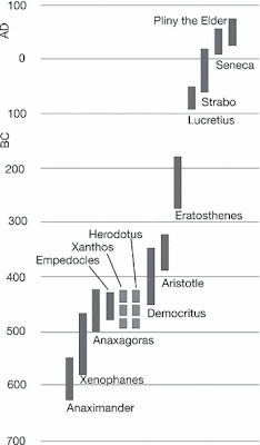
I liked this depiction of the classical Greek and Roman history of Mediterranean geological thought:


Quite a trail of scholarly thinking about geology! I guess when you see lava erupting and the ground shaking, events that happened quite frequently on the time scale of the classical Greek and Roman periods, someone is bound to have a revelation or two about the workings of the earth. Uplifted shorelines and shell beds also provided fertile ground for geological speculations and discourse and mining for stone and precious metals forced map making and systematic assays of the land around them. There were geological casualties too. Pliny the elder died in the Vesuvius eruption of 79 A.D.

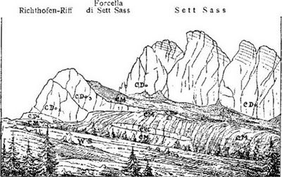
The tradition of inquiry has continued in to modern times. From my own field of study of sedimentary carbonates, the Mediterranean offers some of the best study areas. There are mountain size outcrops, spectacularly exposing shoreline to basin transects. A carbonate sedimentologists dream of examining in detail lateral facies changes. Take a look at this field sketch from 1879 which shows interfingering of shallow and deeper water carbonate facies.


The CD refers to the shallow water dolomite and the CM refers to deeper water muds.

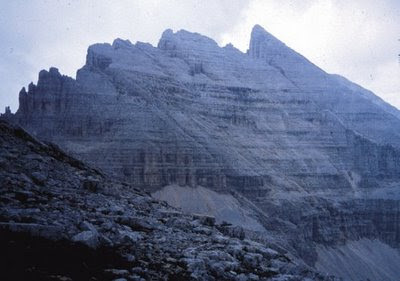
And this section which show parallel bedding which can be traced laterally for long distances.


I was always jealous of the lucky S.O.B's who got to work here. Hey, in the southern Appalachians we had to settle for what little road cuts and a few streams offered us.

I ended up reading quite a few studies on shallow platform carbonates and the link between orbital cycles and sedimentary rhythms. There was Alfred Fischer's unrivaled study of the cyclothems of the Alpine Triassic. These deposits were later evaluated by L. A Hardie, R. Goldhammer and others as a test case of orbitally forced cyclicity. The issue is still not settled as its been tough to link shallow water sedimentary rhythmics to specific orbital cycles due to conflict in radiometric data. The deeper water cycles though have been conclusively shown to be orbitally forced.

And then there was dolomite....

Mixed meteoric marine?.. marine?.....direct precipitate? ....secondary replacement?... hydrothermal?......All models have been applied to explain the dolomites of the Alps. This issue has two papers on the dolomite facies of the Alps and the dolomite problem . Many workers now want to explain the massive dolomite as microbial precipitates. Good luck..

...The debate rages on decade after decade.

Aside from this technical journal, on the popular literature front Walter Alvarez has just published a book on Italian geologists and their many contributions.

A region so geologically active both in thought and process deserves attention like this.

Monday, April 13, 2009

Nice Demo of Google Latitude

Here's a nifty video demonstration of Google's new service Latitude


Tip: Spatial Sustain

Anyone tried it?

So now not only can you broadcast your location but also provide a spatially enabled status drip of your very interesting life to followers.

I don't know if the Google service provides a status thread like twitter but if it did here's what my Google Latitude location map combined with my twits would look like:


All those twits (no no ..not my followers) are geocoded. So if you want to know where I was when I made any particular broadcast, just click on that entry and my mugshot will move to that location. Does Latitude allow that?

By the way here is a wicked rant by Matt Labash against Facebook and social networking in general.

Thursday, April 9, 2009

Human Migrations: Were Harappans Indigenous or Migrants?

Harappan age - 2500 BC to 2000 BC - graves with skeletal remains along with pottery and other artifacts have been discovered at a site in Farmana, Haryana about 60 km from Delhi. There are 70 graves discovered so far say researchers from the Deccan College Post Graduate and Research Institute Pune. The graves are part of a big housing complex, a sign of urbanization of Harappan society by 2500 BC.

The lead researcher Vasant Shinde on this discovery:

“With a larger sample size it will be easier for scholars to determine the composition of the population, the prevalent customs, whether they were indigenous or migrated from outside,”

“DNA tests on bones might conclusively end the debate on whether the Harappans were an indigenous population or migrants.

The DNA testing is to be done at the The Research Institute for Humanity and Nature, Kyoto Japan.

Well good luck to finding out whether these people are indigenous or migrated from outside. Whether someone is indigenous or a migrant depends on the time line you choose. In terms of migrations that may have left a distinct cultural impact of Indian societies, a convenient dividing line would be to regard people entering India before the Holocene as indigenous and those that entered India after the advent of agriculture post Holocene i.e. after around 8000 -10,000 years ago as migrants. So far the genetic profiles of Indian populations tell a complex and mixed story. Mitochondrial DNA evidence indicates that modern humans have been resident in India /south Asia from as early as 60,000 years ago. In that sense Indian people are indigenous to this region. The story gets complicated though. A recent study of the genetic profiles of south Indian castes shows that whether a particular sample shows an entirely indigenous character or affinity towards Eurasian or SE Asian populations depends upon which genetic material you are looking at.

If you take total ancestry measures using autosomal genetic material then Indian subpopulations are more closely related to each other than to European or S E Asian populations. That would indicate that castes and subpopulations have a common origin and underwent a long period of differentiation from Eurasians and SE Asians . This accords well with the MtDNA date of a very early human presence in India. The genetic distance map below shows Indian populations cluster together and are seen to be genetically distant from European and SE Asian populations, although SE Asians seem more like an outgroup.


Source: via Gene Expression - Genetic variation in South Indian castes: evidence from Y-chromosome, mitochondrial, and autosomal polymorphisms

But if you take only say the paternal ancestry using certain Y chromosome genetic variants then an affinity toward Western Eurasian populations is seen among even south Indian castes.


Source: via Gene Expression - Genetic variation in South Indian castes: evidence from Y-chromosome, mitochondrial, and autosomal polymorphisms

This suggests gene flow mediated by migrations of males between Indian and Eurasia. This is a highly controversial finding as people would immediately point out to the migration of Indo-Aryan speaking people from Iran / Central Asia and elite dominance as the event which has caused this pattern. This affinity though is visible only within a particular type of variant on the Y chromosome . The majority of Indian Y chromosome variants show very high diversity which indicates that they are quite old, certainly pre-Holocene and arrived here before historically documented human diffusion between Eurasia and India. So evidence of exogenous gene flow in historical times is an overlay on an essentially Indian genetic substrate. The fact is that Harappan society which most historians agree is pre-Aryan shows plenty of evidence of cultural exchanges with Eurasia. Artifacts point to trading links between Harappan people and Iran and Mesopotamia. And it is likely that males played a bigger role in these trading ties. Indian deep history and more recent history has always been a story of people migrating, of cultural diffusion and .. of gene flow.

I doubt whether DNA analysis will definitely tell whether the Harappans were either totally indigenous or rank outsiders. My money is that they were like the rest of us living Indians, mostly native but with little pieces from outside as well.

Monday, April 6, 2009

Nice Talk On The Origins Of Life and Astrobiology

From NPR Science Friday a talk on Astrobiology and the Origins of Life.

This is before a live audience at Arizona State University, Tempe. So there is a lot of interaction between the scientists and the audience and also callers across the U.S. Guests are Peter Ward a biologist from Univ. of Washington, Paul Davies Cosmologist, Physicist, Astrobiologist from Arizona State Univ, Barry Blumberg Winner, 1976 Nobel Prize in Physiology or Medicine and Founding director, NASA Astrobiology Institute and Ariel Anbar, Principal Investigator, NASA Astrobiology Institute team at Arizona State University.

Two points stood out for me:

1) Where are earth rocks older than 4 billion years likely to be best preserved . Answer - The Moon! Early in the evolution of our solar system, meteorite bombardment of planets caused ejecta to travel and contaminate other planets and their satellites. On earth, rocks that old have been recycled and reconstituted , but the moon has been geologically inert for more than 4 billion years. About 1% of the Moon's soil is extraterrestrial in origin. So material from Venus, Earth and Mars is out there in the Moon's top soil layers.

2) Alien life does not necessarily mean life of extraterrestrial origin. There is the intriguing possibility that life evolved more than once on earth. Only one type proliferated, but is it possible other truly "alien" life forms, those that had an origin independent from our lineage still exist on earth? The point was made that most microbial life on earth has not yet been cataloged and we still have only a dim idea about life's variability. What would such "alien" microbes be made up of and what are the best places to look for them?

A very interesting topic and a great example of science outreach.

Download the podcast and listen.

Friday, April 3, 2009

Permian Subpolar Carbonates Are Cool Too!

From the high priest of cool water carbonates Noel P. James and colleagues, a paper in the March issue of Journal of Sedimentary Research:

Carbonate Sedimentation in a Permian High-Latitude, Subpolar Depositional Realm: Queensland, Australia

High-latitude carbonate rocks that formed in subpolar Paleozoic oceans contain critical information about past climate, but they are neither well documented nor fully understood. Lower and middle Permian limestones that were deposited in such paleoenvironments at 45°S to 55°S along the southeastern margin of Gondwana are now exposed in eastern Australia.......


....All of the carbonates are distinguished by a low-diversity, high-abundance heterozoan biota with no phototrophs and express a recurring deepening-upward stratigraphic motif that is interpreted to reflect rising sea level accompanying glacial meltdown. They also record a strong poleward gradient of increasing ice-rafted debris, increasing skeleton size, decreasing invertebrate diversity, decreasing epifaunal calcareous benthic foraminifers, and reduction in crinoids;......

...express a recurring deepening-upward stratigraphic motif that is interpreted to reflect rising sea level accompanying glacial meltdown.

That seems to be the big difference between the large scale stratigraphic style of tropical carbonates from temperate carbonates. Tropical carbonate sequences record a shallowing up motif. This is because invariably carbonate production is so prolific in warm CO2 degassing waters that it keeps pace with or even outpaces relative sea-level rise. The sediment surface aggrades and fills up the accommodation space before new space is created either through a sinking basin floor or a rising sea-level.

Temperate water carbonate production is slower. This is because in colder water dissolved CO2 doesn't escape solution so easily. Colder sea-water is not as saturated with calcium carbonate as tropical warm sea-water. The biota too is impoverished. So a slower calcium carbonate skeleton production rate is a primary reason why sea level rise outpaces the accumulation of sediment.

There could be another reason applicable to this particular area. The basin faces southwards towards the poles. If these areas located 45°S to 55°S were exposed to severe storms there might be very significant transport of carbonate sediment into deeper and other areas of the basin from the locus of deposition. The sediment surface even if it were aggrading would be kept below storm wave base by persistent storms.

Storms affect tropical carbonates too. Large volumes of sediment is washed into the adjoining periplatform deep waters. But production is so high that the sediment surface shallows up anyway.

I'm just speculating here. It might help if I actually read the paper !

Wednesday, April 1, 2009

Human Migrations: Females Entered India Before Males

Theories of human presence and migration into and out of India have always been controversial. Were the Aryans indigenous to India or did they migrate from central Asia? Was there an invasion and subjugation of local populations or co-habitation and slow assimilation?

Now researchers have gone even further back in time and added another chapter to the story of human evolution in India. Evolutionary biologists and geneticists from Dept. of Evolution and Ecology, University of Patna say that they have pinpointed using mitochondrial genes and Y chromosome genes the dates of the first human migrations into India.

Mitochondria are inherited through the female line. The analysis shows that the mitochondrial coalescent i.e. the date of the most recent common ancestor of living mitochondria in India is about 60,000 years ago. On the other hand the coalescent for the Y chromosome, genetic material inherited only through males is about 30,000 years old in India.

The lead researcher Dr. Adi Manav said that this shows that human females migrating out of Africa entered India before males. The pattern is unmistakable he said. Early human females were smarter and more adventurous than males.

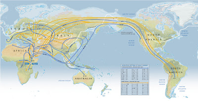
The map below shows the migration patterns of females and males mapped using different mitochondrial and Y chromosome markers.


Asking the media to stick to the facts and not to indulge in dramatic and sensational reporting Dr. Adi Manav said that they were still working on some minor details like how a female only population managed to survive for about 30,000 years without male presence.

He added confidently that :

Genetics doesn't lie. In keeping with the highest traditions of scientific inquiry at Univ. of Patna, now that we know what definitely happened we will come up with a story for how it happened.