Wednesday, August 27, 2008

Kosi Breaches Embankment, More Water Refugees In Bihar

I wrote sometime back that although there are been much focus in the media and also concerns raised in the National Action Plan on Climate Change (15 mb) about sea-level rise and coastal populations being displaced, the interior of the country will also see its share of water refugees as climate and environments change. A couple of months ago, a prolonged drought in the Bundelkhand region whose effect was amplified by decades of neglect of water conservation measures lead to a massive dislocation of people in the affected areas. Now, Bihar is witness to another wave of people fleeing a water crises, this time a near catastrophic flood of the Kosi river.

Nearly 2.5 million people living in the Kosi flood plains have lost everything, as the river broke through its constraining embankments near Kusaha village in Nepal on August 18 and flooded several districts in Bihar. See map below for a synoptic view.


As you can see the Kosi forms an alluvial mega-fan, a massive triangle shaped body of sediment which you can distinguish from adjacent environments due to the closely spaced meandering network of channels between the present day Kosi river and Basantpur to the east. Such sedimentary deposits form when rivers suddenly change gradients as the Kosi does when it flows out of the Himalayas into the Indo-Gangetic plains. This fan is enormous, about 180 kms long and 150 km wide. Westward tectonic tilting of the entire area has been the major controlling factor for the river shifting its course about 120 km from east to west over the last 250 years. I have labelled the various paleo-channels using this study as a rough guide.

About 10-15 million years ago rivers bringing sediment from the rising higher Himalayas formed similar alluvial fans in a depression where today the Siwalik mountains stand. The Siwaliks are made up of sediments of such ancient alluvial fans that - as the Indian plate pushed against the Asian plate - have been consolidated, hardened, compressed, deformed and uplifted to form undulating mountains. The locus of sedimentation has now shifted in front of the Siwaliks. The Himalayas are growing southwards. There is nothing more awesome than the geological forces that give shape to this dynamic planet.

The Kosi has breached the embankments before but they have been downstream of the barrages and canals that are used as safety valves. Engineers have been able to control floods by diverting water to the canals. But this breach occurred upstream of the barrage and canal system giving engineers no way of controlling the excess flow. The river has occupied one of the abandoned channels to the east of the present day channel as seen in the image below taken on August 24 2008.


Source: NASA Earth Observatory

I couldn't make out exactly which paleochannel from the image but the district of Madhipura has experienced the worst flooding, so could be one of the channel close to that village. It will be months before the embankment is plugged and the river returns to its original course. Meanwhile hundreds of thousand of people have become water refugees. I don't know how many will go back. It is possible that the topography and recognizable landforms will change significantly to make identifying the tiny plot of land that is farmed a messy process. In short the future looks bleak for large number of people especially those with no clear titles to land and there are plenty of those in Bihar.

The Kosi is such a dynamic system that people living along its flood plains will always face this risk. Embankments don't offer a permanent solution to flood control. The danger is that global warming might make the monsoons more erratic at the same time resulting in more concentrated periods of rains. Coupled with increased summer melting due to the accelerated decline of Himalayan glaciers, the situation will strain the capacity of embankments to hold the river back. It is a question of when not if till the next embankment failure.

High dams in Nepal have been proposed as a "permanent" solution. This experts say will result in better flood control. The worry is the extremely high sediment load carried by Himalayan streams. For example the life span of the Tehri Dam in the Gharwal Himalayas is now being reassessed to being only about 30-40 years as against the older estimate of a 100 years. Dams on the Kosi river will no doubt also be short lived. What will we do after the dam fills up with silt?

But then what can be done? I don't know. The problem really appears intractable for the near future. India simply does not have enough excess arable land to relocate people living in high risk areas like the Kosi flood plain. I mean where can these people go? In developed countries like the U.S. high risk areas seem to be serving as a magnet for people to settle in large numbers. Katrina has not stopped people from returning to New Orleans, and people still seem willing to relocate to Florida in the path of hurricanes and California in earthquake prone zones.

Over here people do return to areas of disaster but because they have little choice. It's either farm these plots or live in slums in big cities. Livelihoods, land use and habitation patterns will change slowly but until then the best we can do is set up better early warning and disaster management systems. This will hopefully save lives, but the problem of loss of property and livelihood remains.

Monday, August 25, 2008

Teaching Evolution in Florida and About Pseudo-Science in India

New York Times science writer Amy Harmon has a long article on the day to day reality faced by biology teachers as they try to explain evolution to students hostile to the very idea of evolution as the unifying principle for understanding life. The articles focuses on Florida because of a recent Florida Dept. of Education decision to make teaching and testing students in evolution mandatory in public schools.

This is eye-popping unbelievable:

With no school policy to back him up, he spent less time on the subject than he would have liked. And he bit back his irritation at Teresa Yancey, a biology teacher down the hall who taught a unit she called “Evolution or NOT.”

Animals do adapt to their environments, Ms. Yancey tells her students, but evolution alone can hardly account for the appearance of wholly different life forms. She leaves it up to them to draw their own conclusions. But when pressed, she tells them, “I think God did it.”

It's impossible for students to receive good science education if the teacher doesn't understand what science is in the first place.

Most of the article follows David Campbell a biology teacher who played a role in determining the new evolution standards, as he tries his best to explain evolution as theory and fact. Many students are not convinced. How can they when:

But in a nation where evangelical Protestantism and other religious traditions stress a literal reading of the biblical description of God’s individually creating each species, students often arrive at school fearing that evolution, and perhaps science itself, is hostile to their faith.

Some come armed with “Ten questions to ask your biology teacher about evolution,” a document circulated on the Internet that highlights supposed weaknesses in evolutionary theory. Others scrawl their opposition on homework assignments. Many just tune out.

There is serious indoctrination of children in dogmatic beliefs by church and at home. It's an uphill battle but one that science must win to prevent an entire generation growing up without a proper understanding of how the natural world works and how humans are an integral part of it.

On a related but different note, Selva asked in response to my post on astrology and earthquakes

Why do so many seemingly educated people - people who have been trained in the scientific method - have a soft spot for astrology in India.

The article was about an engineer and aspiring astrologer and if by educated people Selva meant engineers and doctors, my answer would be that it is so because many educated people, often those with higher technical degrees have never really received an education in the scientific method. You may well receive a degree with distinction in Engineering or even Medicine but that does not necessarily mean you have a training in the scientific method. Technical degrees don't spend any time on this kind of education.

Add to that is the pervasive influence of religion and mysticism children experience in our society. The rot probably starts at school level. We just don't have a systematic, aggressive science education programme to combat beliefs like astrology. I won't be surprised at all if many teachers in India express an "Astrology is a science" opinion similar to the "I think God did it" belief of Ms. Yancey of Florida. We may not teach astrology in school but we don't provide students with training to critically analyze pseudo-scientific claims either.

India's Medal Tally, Maybe Not That Bad?

Evolving Thoughts has a revealing graph of medals won by countries normalized by population. Gold medals per million and overall medals per million. Only countries who won at least one gold are considered.

Guess which country comes last

Source: Evolving Thoughts

But I find this comment more encouraging. What if we plot a graph of medals to expenditure. A sort of measure of return on investment. I suspect India will come off much more honorably. If we consider only government expenditure we might even come out on top, since many of our athletes spent their own money for training. And by government expenditure I mean the money actually spent on athletes, not the total budget, since much of it is likely squandered on bogus conferences, "study tours" and other expenses for the parasitic sports officialdom. Anyone with the numbers?

Wednesday, August 20, 2008

Identifying Descendants of the First Humans in India

When did Homo sapiens enter and settle in India? What was their subsequent population history? Can we identify the descendants of the first settlers in contemporary Indian populations or has subsequent migrations removed any genetic evidence of the pioneers? Anthropology.net has a post on research which adds to our understanding of these questions.

Mitochondrial DNA (MtDNA) has been used quite extensively to trace the genetic ancestry of populations. MtDNA has some advantages in such studies. MtDNA is passed down independently of the nuclear genes. It is not subject to the recombination that results in different parts of the chromosomes being swapped around over generations. MtDNA in contrast is inherited as one unit. Different genes on the mitochondrion therefore have experienced the same history. Such chunks of DNA passed down as single units are called haplotypes. Also MtDNA is passed down only via the female line and so you would be tracing your maternal ancestry. This makes tracing your ancestry using MtDNA less complicated than using nuclear genes.

Now populations isolated from other populations will be evolve over time a unique set of variations on their MtDNA which will define a particular MtDNA haplogroup. If you compare the MtDNA of one population with another you should be able to tell from the differences they have accumulated and our understanding of the mutation rate of sections of MtDNA, how long ago they shared an ancestral mitochondrion. These are the types of studies that this recent research has done on MtDNA on several tribal populations of India. Tribals were chosen because cultural, ethnographic and linguistic studies indicate their ancestors may be early settlers of India and they appear to show the least amount of mixing with later immigrants. So they offer the best chance of preserving genetic signals of the earliest settlers.

This research has shown that several of the sampled tribes for example the Korku and the Kuruba contain a high frequency of the M2 haplogroup, which using the tracing back of genes method I mentioned has been found to have originated around 50,000 years ago. The M2 itself belongs to a larger family of MtDNA lineages within the M macrohaplogroup, which is thought to be a descendant of the African L macrohaplogroup. This indicates that populations migrating out of Africa around 50-60,000 years ago entered India, became isolated from other Asian populations and evolved a unique M haplogroup out of which M2 is the oldest lineage. Figure below shows the distribution of the M2 haplogroup in the sampled tribes.


Source: The earliest settlers’ antiquity and evolutionary history of Indian populations: evidence from M2 mtDNA lineage

So the picture seems to be that there is a 50,000 year old genetic continuity of the female line preserved in some tribal populations, making them likely descendants of the first Homo sapien settlers in India. Notice the near complete absence of M2 from northeast tribes. Did the immigrating population not settle the northeast? Maybe a species adapted to a woodland-savanna ecology may have initially found it difficult to occupy a mountainous thickly forested terrain. Or were there original settlers in the northeast also but who were later removed or assimilated by more recent immigrants?

And what about human presence in India before 50,000 years. There is plenty of evidence of that too. But that human belonged to an earlier species Homo erectus, which also migrated from Africa. The tool record of erectus in India goes back to 1.2 million years ago. Did the immigrating Homo sapien populations encounter resident Homo erectus populations. Could they have interbred or had erectus already gone extinct. Unfortunately we don't have any fossils of erectus to tell us any details of its presence in India. But can genes tell us anything more? The mitochondrial trail goes back only 50,000 years, but could there be other genes in Indian populations of even more ancient ancestry?

Sunday, August 17, 2008

Happy First Blogiversary To Me

No, it is not today. It was two weeks ago but I missed it!

Its been just over a year since I started this blog. My motivation to start writing was really a personal one. I like writing about science. The decision on what topics to concentrate on was also easy. I am passionate about geology and evolution and there was never any doubt that these would be the central themes of this blog. I decided early on to concentrate on discussing the science itself. Geology and evolution are not widely read in India and although the blogosphere crosses national boundaries and reaches audiences worldwide I did have in mind primarily Indian readers. There is definitely a lacuna in covering these topics in Indian science writing of any sort and so I hope this blog is helping bridge that gap a little.

The choice of these topics and writing primarily on nerdy science stuff did mean narrowing the size of the potential audience but that is something I expect and accept. I remember a conversation with a geology faculty during my Master's training in Pune. He emphasized that once you are specializing in science you will start living in a self contained universe, corresponding and interacting with a very small group of people. You love what you do, you have to strive for quality and not worry too much about how many people read your work. It will be a very small number. I thought about that when a grand total of about 8 people read my PhD thesis!

That was before the blogosphere erupted. Today a super specialized scientist can publish a paper that 8 people read but simultaneously publish a blog post which is read by thousands. I can't claim that my posts are read by thousands, but it is something to strive for. It's good to know that there is a large audience for good science writing, even writings on very specific topics. I guess today my blog is doing okay for such a niche subject area. More than 8 people have read my writings and I have a small but growing subscriber base. I would love to have more readers and more interaction with science fans. I would love to have the Indian media read my posts and improve their coverage of science. Yeah, dream on!! That's hoping for too much!

But I do hope to keep writing and it will be interesting to see if my blog remains engaging enough to entice more readers to spend a few minutes of their busy day visiting this site.

Friday, August 15, 2008

Geoscience Salaries And Careers in U.S and India

I came across several articles on geology careers in the U.S. These appear to be boom times for geologists with the oil and gas and mining industries in U.S and Canada on a hiring spree. The table below summarizes geo-science employment stats and salaries in the government and private sectors.


Source: Sciencemag Careers

Here are the links to three articles on geology and hydro-geology careers in the U.S.

In the Geosciences, Business Is Booming
Geoscientists in High Demand in the Oil Industry
Hydrogeologists Tap into Demand for an Irreplaceable Resource

The three articles give you a good idea about the state of the geology market in the U.S. There are some parallels with what is happening in India. Although statistics about the Indian geology market are hard to come by, I keep talking with friends and colleagues who are in the industry and academia and so I have a fair idea of demands and hiring trends.

Just as in the U.S., geology graduates are finding that their skills are in demand in the oil and gas sector. However unlike North America where even a strong bachelors degree can land you a high paying oil job, in India only Masters level students are hired. Maybe that says something about the standard of bachelor level training in India where state colleges do not always offer the best quality geology training. Starting salaries are nowhere compared with the U.S. In Indian money they come to about Rs 2-5 lac per year (range equivalent to about $5 K to $ 12 K).

Another parallel is the relative stagnation in academia. In the U.S. falling research budgets has lead to many Universities not hiring replacements when a senior faculty retires. A survey shows that the number of geoscience faculty is down to 12,354 today from a figure of 13,554 in 1999. In India again there is a problem of a flat hiring trend in academia but probably for a different reason. A large number of vacancies are only to be filled by reserved category candidates (i.e reserved for candidates from India's backward classes) and many geology departments have difficulty finding suitably qualified candidates with a Ph.D in geology to fill these posts. Starting salaries in academia are less than what oil and gas pays.

One difference that emerges between the geology markets in the U.S and in India is in the environmental geology field. There is a tremendous demand in the U.S for geologists in the environmental consulting field. Hiring is strong both in governmental agencies as well as the thriving private environmental consulting sector which hires about 80% of hydro-geologists. A wide variety of skill sets are in demand to deal with various water resources (both water quality and resource management) and environmental problems and increasingly climate change related impacts on the environment.

In India environmental geology has never been a marketable skill primarily because India until very recently has not had strong environmental regulations in place. Government geology agencies have not developed well funded environmental geology programs, since dealing with water quality, water resources and myriad other environmental issues has not been given priority and backing. Consequently the private environmental consulting business has also seen small growth for geologists, since most such businesses end up servicing government contracts.

There are however two areas in which geologists have been making an impact in the environmental field in India. One is groundwater prospecting where solo operators armed with electrical resistivity measurements and a strong knowledge of local geology have built successful careers. My experience at least in the state of Maharashtra has been that most of them are genuinely skilled. Occasionally you do come across scamsters given to theatrics like using a magnetic compass to "point to water" or even dowsing. But most seem above board. The other area and one which is rapidly growing due to the infrastructure boom is in geo-technical services, essentially geology consulting for building foundations, road alignment, slope stability, tunnel excavations, all engineering geology applications.

Geology jobs in India traditionally have been mostly with the government. That is changing with private oil and gas and mining companies being allowed in the Indian market. There is also a growing awareness at the highest political levels that India is facing enormous environmental problems, a legacy of several decades of neglect. Multi-national companies setting up shop here will one hopes bring more stringent environmental impact assessment and remediation standards. That along with a concern for global warming and its impact on water resources, I hope will open up new niches for geologists.

Monday, August 11, 2008

Nyah Nyah Lomonosov Is Ours Says Canada

No they didn't quite put it that way. After last year's dramatic planting of it's flag on the north pole sea bed by Russia to draw attention to its interest over the resource rich Arctic sea floor, you would think Canada would have retaliated with something equally spectacular, but no, the announcement when it comes will be sober and scholarly:

Crustal Structure from the Lincoln Sea to the Lomonosov Ridge, Arctic Ocean will be how Canada makes it's case at the 2008 International Geological Congress in Oslo for sovereignty over the Lomonosov ridge, a vast undersea ridge thought to be composed of continental crust stretching from Ellesmere Island and Greenland to Siberia.


Countries have exclusive right over mineral deposits extending to 200 nautical miles from their coasts. This zone can be extended if any country can prove that their continental shelves (which are composed of continental crust) extend to a distance more than 200 miles. Russia claimed that the Lomonosov ridge is a natural extension of Siberia sometime back, now Canada along with help from Denmark is trying to demonstrate that the ridge is part of the North American plate. The critical piece of evidence will be the nature of the contact between the ridge and the North American and Siberian continental crust. On the Siberian side the geology looks to be quite complicated, the contact between the ridge and the Siberian shelf is faulted. This may be because the ridge originally came from a different part of the Eurasian shelf and has over the last few million years slid along a transform fault to its present location. Are transported terrains in faulted contact to be considered part of the natural extension of the shelf? I don't see why not. In the absence of oceanic crust in between the two, the ridge has become a natural extension of the shelf. It will be interesting to follow what evidence the Canadians have that shows geological continuity between Ellesmere Island, Greenland and Lomonosov.

There is a lot of energy locked in various Arctic basins. Lomonosov is only part of the overall exploration and assessment by circum-Arctic countries of resources that may become easier to exploit as global warming melts Arctic ice. A recent assessment by the United States Geological Survey of undiscovered oil and gas resources in the Arctic suggest that up to 90 billion barrels of oil and 1,669 trillion cubic feet of natural gas may remain to be discovered. Out of this about 84% of the resources may occur offshore. The table below summaries the USGS study.

Denmark has a lot to gain by collaborating with Canada over Lomonosov as several Greenland (which Denmark administers) and adjoining Canadian basins look to be exceptionally rich in oil and gas, containing possibly up to 17 billion barrels of oil. Lomonosov at least according to this USGS study may contain much less oil (1.1 billion barrels) than some other basins over which issues of sovereignty are settled. Experts feel it unlikely that any one country will end up with sovereign rights over Lomonosov. Expect a three way split between Canada, Denmark and Russia.

Tuesday, August 5, 2008

Geology Lessons To An Astrologer

Once again I find myself writing on a geology topic which has made recent news in the Indian media. I am referring to the belief held by some people that a particular alignment of the moon and planets is the cause of major earthquakes. This belief holds that plate tectonics and the earth's internal stresses play a minor role if at all. Astrology and the influence of the gravitational pull of the moon on our daily lives and now apparently the internal working of the earth is a topic that seems to fascinate a lot of people. The reaction I get when a discussion starts is a lot of head nodding and muttering that "there must be something to this" and occasionally a long confident but utterly nonsensical monologue on geology, gravity, tidal forces and earthquakes. Then how do you explain that the Bhuj earthquake took place during full moon? Coincidence is something that believers seem not to believe in.

I did some more searching for tidal triggering of quakes and found out that there has been some recent work that suggests a relation between tides and ocean tidal loading triggering small seismic shocks, but all these studies indicate that tectonic stresses play the major role and tidal stresses if at all a minor one. Researchers are suggesting that tides may raise the level of stress on faults and cause them to slip sooner than they would have. The earthquakes would have happened without the tides, but the additional tidal stresses may be helping it occur sooner. This is similar to the situation of reservoir induced seismicity, where the column of water in a reservoir may increase stresses on already critically stressed faults causing them to slip. So you cannot explain earthquakes as Mr. Dave is proposing by ignoring the tectonic setup. And in any case the mechanism Mr. Dave proposes for tides causing big earthquakes is not viable.

A while ago DNA had an interview with a Mr. Amit Dave who claims he can predict big earthquakes based on the alignment of planets. I criticized that article and pointed out the many mistakes and misunderstandings about geology that Mr. Dave 's theory was based on. I have gotten no substantive reply from him but he did leave a list of question for me in the comments section. Instead of replying to him in a comment I thought I would write a new post. Below is the list of questions:

A few question to MR.kher

(1) Does moon force depend on the body it is acting?
(2) How such a small force produce 4.5 mtrs of high tide in the oceans?
(3) can we observe high tide and low tides in a bucket full of water? why ?
(4) Does mass and volume of molten lava is more than that of waters in the oceans?
Now some questions to Plate Tectonics
(1) Why there are quakes at other than plate boundaries?
(2) How and why the initial two plates ie Laurasia and Gondwanaland
separated initially ? Due to heat currents or Due to Earth rotation?
Because magma will not solidify at the places where splitting forces are already there how did they separated ?
(1)Why there are major quakes allover the globe ,on different plate on a given date?
(2) Why some months are prone to major natural disasters Like May 2008?
(3)Why some of the major quakes have occured onf
full moon or new moon day. BOth Latur(30-09-1993) and Bhuj 26-01-2001)quakes are on full moon day
(4) How does plate tectonics explains pre shocks ?

It seems like a pretty confused and badly framed set of questions.

I'll lump the first two questions together:

(1) Does moon force depend on the body it is acting?
(2) How such a small force produce 4.5 mtrs of high tide in the oceans?

All objects on earth experience gravitational attraction to the moon. The moon's force is very small, about one ten millionth the gravitational pull of the earth. However, the water in the oceans is not rigid. It flows and the earth cannot hold on to it like it does to the rigid crust. The moon is able to pull at it and this gravitational pull along with the centrifugal force created by the earth's spin results in a piling up of water on the side of the earth facing the moon as well as on the side opposite it. Whether tides are 4.5 meters or less or more depends upon the location of the sun and the moon, the particular configuration of the coastline, depth of the ocean at that location and oceanic currents.

3) can we observe high tide and low tides in a bucket full of water? why ?

And do mentally unstable people become even more insane during full moon? And oh, did you hear about that Olympic swimmer who was dragged to the other end of the swimming pool by a low tide? All these are myths, tidal forces don't affect objects over small distances.

This is the key to understanding why large earthquakes cannot be caused by tidal forces acting alone on earth.

Tides are created not by just the gravitational pull of the moon but due to a difference in the gravitational pull of the moon across the body of the earth. The gravitational forces decrease with distance and so an object on the side of the earth closer to the moon will experience a slightly larger pull than an object at the center of the earth, which in turn will experience a slightly larger pull towards the moon than an object on the side of the earth facing away from the moon. The near side of the earth accelerates towards the moon a little faster than the center of the earth producing a tidal bulge on the near side. The solid earth bulges out only a little, maybe a few cm, but the more fluid water produces a bigger tidal bulge. Now the oceans on the far side are being pulled toward the moon less than the center of the earth. This difference causes the oceans to be "left behind" to form a second tidal bulge as the moon pulls the earth away from the oceans on the far side.

So small differences in the gravitational pull of the moon (and sun) realized across the body of the earth i.e over very large distances causes tides.

Now it is easier to understand why small bodies of water like that in buckets, swimming pools and lakes do not experience tides. It is because the water at different locations across these bodies is at the same distance from the moon and experiences no difference in gravitational pull.

4) Does mass and volume of molten lava is more than that of waters in the oceans?
At any one time the mass and volume of lava being produced is smaller than that of the water in the ocean. His theory of earthquakes depends upon tidal forces acting on molten material and causing it to disrupt the earth's crust. This is what DNA quote's him saying:

The earth consists of a thin upper crust and molten lava, magma. The inner crust is semi-solid and hot. Like tidal waves, this molten lava is also influenced by tidal currents. The moment the high tide pull is more, it breaks open the crust and earthquakes occur. If the crust breaks completely, it results in a volcanic eruption. Dave says the most potent quakes occur when the sun, Jupiter, Saturn, and the moon are in mutual potent positions like 0º, 90º, 180º, and 360º. The two planets change their direction of motion from direct to retrograde from time to time. The gravitational pull exerted on the earth by this movement induces a change in momentum, mass and velocity of the molten lava, creating disturbances.

According to him, in this imagined interior of the earth there is a uniform layer of molten material forming an ocean at depth just like the one on the surface. If the surface ocean experiences tides, then so does this subterranean magmatic ocean. High tides in this magmatic ocean will then exert pressure on the overlying solid crust causing it to rupture. The problem with this fantastic scenario is that the description of the interior of the earth is all wrong. There is no uniform layer of magma at depth. The earth's upper and lower crust is all solid and magma within it occurs as small discrete bodies localized along zones of melting mostly close to plate boundaries.

But wait.., what was it about small bodies of liquid and tidal forces? Yes that's right, the difference in lunar gravitational pull across these local bodies of magma will be small and they will experience no significant lunar tides, certainly not large enough to cause the surrounding crust to break.

Let's now take magma out of the picture. A lot of earthquakes are not associated with magmatism and Mr. Dave's theory fails to provide a mechanism to explain them. Can tidal forces cause solid earth to rupture causing earthquakes? This is not as unrealistic as it sounds. As the comet Shoemaker-Levy 9 accelerated towards Jupiter it broke up into pieces due to Jupiter's tidal forces. What happened was that the front of the comet accelerated towards Jupiter at a faster rate than the far side of the comet. This differential pull across its body caused it to split.

But the moon's gravitational pull is not that strong. Any differential pull due to moon's gravitational force felt by the solid rocks across the earth is easily overcome by the earth's own gravitational pull. Still lunar gravity does cause the solid earth to deform a little (solid earth tides), by just about 2 feet across its diameter. There is just not nearly enough differential gravitational pull across any local region of the earth (the swimming pool or bucket of water principle) which by itself can cause the crust to rupture. Earth tides if they do show a correlation to minor seismicity always act in concert with the regional tectonic stress field.

Now to Plate tectonics part of Mr. Dave's questionnaire

(1) Why there are quakes at other than plate boundaries?
Most earthquakes do take place at or near plate boundaries but there are plenty of examples of earthquakes in mid-plate locations far away from zones of plate interaction. The ultimate cause of these earthquakes can usually be traced to plate boundary stresses being propagated across the rigid crust leading to reactivation of weak crustal zones in mid plate areas. Crustal flow arising out of plate-plate collision zones can also form zones of deformation and earthquakes far away from plate boundaries. The recent Sichuan earthquake is a good example. The figure below depicts crustal flow patterns tracked by GPS measurements across and away from the Himalayan collisional zone.
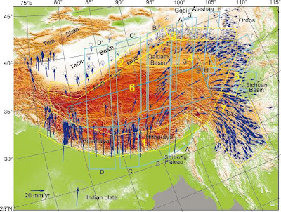

Source: Continuous Deformation of the Tibetan Plateau from global positioning system data

I've explained how plate tectonics can ultimately explain this pattern of crustal flow, deformation and earthquakes in a previous post. Try explaining this using tidal forces.

(2) How and why the initial two plates i.e. Laurasia and Gondwanaland separated initially ? Due to heat currents or Due to Earth rotation? Because magma will not solidify at the places where splitting forces are already there how did they separated ?

The first part is easier to answer since I didn't really understand the second part! How do plates split apart, example Laurasia and Gondwanaland of Pangea fame. The best answer we have is due to mantle convection cells which bring hot material to the base of plates causing doming, weakening of the plate and finally rifting, eventually splitting the plate into two and creating a divergent plate margin. This mantle upwelling and the resultant decompression of the mantle material lowers the melting point of the mantle material causing melting. The melt does not force the plates apart, rather is a result of the rifting of plates.


Miscellaneous:

(1)Why there are major quakes allover the globe ,on different plate on a given date?
(2) Why some months are prone to major natural disasters Like May 2008?
(3)Why some of the major quakes have occured onf
full moon or new moon day. BOth Latur(30-09-1993) and Bhuj 26-01-2001)quakes are on full moon day
(4) How does plate tectonics explains pre shocks ?

All these can be answered in one thread. It also reveals a little of how Mr. Dave thinks. For example his fixation on dates is due to his blind faith that certain days are special because of a preferred alignment of the moon and planets. That's why his insistence on finding out if there is a relation between plates and dates!

Unlike a particular alignment of the moon and planets taking place on certain days, plate tectonics is not an event. It is an ongoing process taking place all the time, simultaneously all over the globe. The earth's plates are moving in different directions, jostling against, subducting underneath and sliding past other plates. This creates different stress fields on different plates and many times pre-shocks (which is nothing but a small earthquake preceding a big one in the same area) and large earthquakes on the same day. There is nothing special about these occasions. Rocks along faults situated on different plates may just happen to slip on the same day. A chance clustering of such events may make certain months seem more prone to earthquakes, but if one takes a large enough data set things even out.

Finally Mr. Dave left another comment on a previous post :

As you all have agreed that there could be major quakes in September 08 ,or for that matter in any month,why you people hesitate in giving three dates

He wants me to give him three random dates and check whether both of us have the same probability of success or failure. Scoring brownie points over each other using three data points is not how science works. This is his theory. The burden of proof is on him. If he want his work to be taken seriously then he will have to write up his results and present them for peer review. Inviting me to play a game of dice in the blogosphere is not the way to test a hypothesis.

Disclaimer Sept. 17: Contrary to some comments left on this post I did not predict the Sept 17 earthquake which occurred in the Satara district of Maharashtra. Nor did anyone else. Don't let people fool you otherwise. You have to give accurate location information (latitude and longitude) along with a hypothesis in terms of geological forces and stresses acting at that location why an earthquake is likely or imminent. Simply saying that an earthquake will occur on this day and time does not qualify as a prediction. The reason is that there are plenty of earthquakes occurring everyday on earth. On average about 10-11 earthquakes of 6-7 magnitude occur every month, 3 earthquakes of 5+ magnitude occur everyday and more than 20 earthquakes of 4+ magnitude occur everyday somewhere on earth. Without a location and a justification "predicting" an earthquake is easy!! :-)

I'll be writing a larger post on this later maybe in a couple of weeks. Do visit again.

Update: Was September 08 Earthquake Month?